|
||

|

|
|

|
Restricted Flight Chart-Not Intended For Public Release
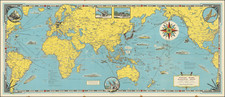
Produced shortly after the surrender of Imperial Japan, this map depicts the route from the strategically important South Kyushu, Japan, to the recently liberated island of Taiwan. Kyushu was a major place for industry and aviation during World War II. One will note such strategic archipelagoes like Okinawa and Sakishima Gunto are included.
The chart contains several key pieces of information that would be useful for anyone flying between islands. The main feature is the list of radio towers and their range. This information was key for the coordination of air missions and communication across the occupied islands. The map also includes elevation data for all land in the area, essential for pilots to understand the topography and adjust their altitude during flights.
The map contains some intriguing pieces of information as well. Notably, there is a marked section that shows the extent of the former Japanese empire. Additionally, Taiwan is noted as a Japanese possession, despite the finalization of the empire's surrender. Another interesting aspect of this piece is the "Restricted" and "Advanced Edition Subject to Correction" notes that appear on the bottom. This implies a limited run of these maps as well as the fact they were never intended for the general public to see.
Although initially designed as a tool for navigation, this map is more than just that. As a historical document, it is a snapshot into the complex political geographical, and technological context of the U.S. and Japan immediately after World War II, offering a glimpse into the strategies and intricacies of aerial navigation during a pivotal period in global history.
Manuscript Annotations
Perhaps the most intriguing part of this map is the penciled-in notations between the western part of Kyushu and Okinawa. These are presumably course directions with heading calculations plotted. The inclusion of these marks indicates this chart was used for multiple navigational purposes between different locations. These lines also explain the condition of the map as this was certainly used to actually plan and navigate flights
![(Second World War - Bombing of Japan) Tachiarai AF RESTRICTED [Three Reconnaissance Photos of Tachiarai Air Force Base]](https://storage.googleapis.com/raremaps/img/small/90451.jpg)


![(Second World War - Sudetenland) Wer Braucht Sicherheit im Südosten? [Who Needs Security in the Southeast?]](https://storage.googleapis.com/raremaps/img/small/98159.jpg)