|
||

|

|
|

|
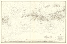
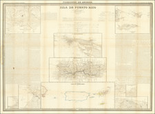
Cram's map represents Puerto Rico divided into seven distinct districts, reflecting the administrative divisions of the time. Each district is represented by a different hue, creating a vibrant mosaic of colors that perfectly illustrates the island's geographical diversity.
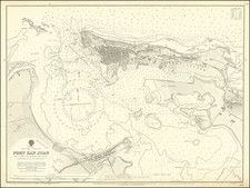
Insets of San Juan, Crab, and Culebra Islands, placed strategically on the map, provide an in-depth look at these critical areas. The San Juan inset is particularly detailed, demonstrating Cram's attention to accurately portraying the island's capital and its complex network of streets, forts, and harbors.
This map was published just a few years after Puerto Rico was ceded to the United States following the Spanish-American War in 1898. In the late 1890s, Puerto Rico was striving for autonomy from Spain. The Carta Autonómica was granted in 1897, providing the island with self-governance. However, this brief moment of autonomy was short-lived as the Spanish-American War broke out the following year. The Treaty of Paris ended the war, and under its terms, Spain ceded Puerto Rico to the United States.
The map reflects this transitional period in Puerto Rico's history. U.S. influence can be seen in the inclusion of English names alongside Spanish ones, signaling a shift in the island's cultural and political landscape. The map subtly indicates the changes in governance and the reconfiguration of administrative boundaries, marking the onset of American imperialism on the island.
Post-1898, the U.S. implemented the Foraker Act in 1900, establishing a civil government in Puerto Rico. The island was treated as a territory rather than a state, and the Act provided a limited form of civil rights to its inhabitants, although they were not granted U.S. citizenship until 1917.
Throughout the first decade of the 20th century, Puerto Rico underwent substantial economic changes, shifting from a subsistence economy to a cash-crop economy centered on sugar, tobacco, and coffee. This period also saw the development of infrastructure, including roads, schools, and healthcare facilities, influencing the life of every Puerto Rican.
George F. Cram (1842-1928), or George Franklin Cram, was an American mapmaker and businessman. During the Civil War, Cram served under General William Tecumseh Sherman and participated in his March to the Sea. His letters of that time are now important sources for historians of the Civil War. In 1867, Cram and his uncle, Rufus Blanchard, began the company known by their names in Evanston, Illinois.
Two years later, Cram became sole proprietor and the company was henceforth known as George F. Cram Co. Specializing in atlases, Cram was one of the first American companies to publish a world atlas. One of their most famous products was the Unrivaled Atlas of the World, in print from the 1880s to the 1950s.
Cram died in 1928, seven years after he had merged the business with that of a customer, E.A. Peterson. The new company still bore Cram’s name. Four years later, the Cram Company began to make globes, a branch of the business that would continue until 2012, when the company ceased to operate. For the final several decades of the company’s existence it was controlled by the Douthit family, who sold it just before the company was shuttered.
![[Puerto Rico and the Virgin Islands]](https://storage.googleapis.com/raremaps/img/small/82657.jpg)
![Cuba Insula [with] Hispaniola Insula [with] Insula Jamaica [with] Ins. S. Ioannis [with] I.S. Margareta Cum Confiniis](https://storage.googleapis.com/raremaps/img/small/95802.jpg)