This item has been sold, but you can enter your email address to be notified if another example becomes available.


|
||

|

|
|

|
Stock# 98014
Description
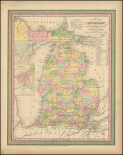
Remarkable large format map of Michigan, published by OW Gray.
Teh map is colored by counties, and shows towns, roads, rivers, lakes, mountains, forts, railroad lines, etc. The railroad lines with each station are identified.
One of the best large format atlas maps of the period.
O.W. Gray Biography
O. W. Gray was a publishing firm based in Philadelphia. Later, they published as O. W. Gray & Son. They published atlases in the late nineteenth century. Gray's National Atlas was one of the most successful commercial ventures of the 1870s and one of the last to employ hand coloring on maps.

![[ First map of Michigan Territory published in Europe ] Carte Geographique, Statistique et Historique De Michigan](https://storage.googleapis.com/raremaps/img/small/99266.jpg)