|
||

|

|
|

|
Stock# 98004
Description
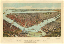
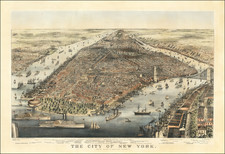
Scarce early hand-colored lithographic view of New York and Brooklyn, published by Locher in New York City and St. Gall, Switzerland.
The map captures the vibrancy of the New York Waterfront, with Brooklyn to the East and Governor's island at the southernmost tip of the map.
Castle Garden, Battery Park, City Hall Park, Broadway, and Manhattan's already booming metropolitan scene is apparent.
Condition Description
Backed with a thin layer of tissue. Minor tears and marginal losses expertly reinforced and restored.
![[ East Village Art Scene ] Artropoly East Village 85. A guide. A documentary](https://storage.googleapis.com/raremaps/img/small/55849.jpg)
![[Gustave Eiffel's Drawings and Blueprints for the Statue of Liberty]](https://storage.googleapis.com/raremaps/img/small/58964.jpg)