


|
||

|

|
|

|
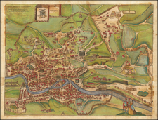
Important large plan of Rome, detailing is architectural history, drawn by Paul Letarouilly.
The Plan de Rome Moderne, authored by the distinguished architect Paul Letarouilly, is a testament to the confluence of historical preservation and urban documentation in the 19th century. As an integral part of his extensive oeuvre, particularly the acclaimed Edifices de Rome Moderne, Letarouilly's map meticulously charts the city of Rome with an attention to detail that reflects both the academic rigor and the aesthetic sensibilities of its creator.
Letarouilly devoted thirty-five years to the study and illustration of Rome's architecture, a period marked by careful observation and the cultivation of an intricate knowledge of the city's topographical and structural nuances. The 1838 map thus serves as a culmination of these efforts, delineating the boundaries of Rome's districts and identifying key architectural sites with precision. Its dual legends, rendered in both Roman and Arabic numerals, invite an analytical engagement with the city's layout, offering insights into the juxtaposition of Rome's ancient ruins against the backdrop of its modern edifices.
The map's significance is further underscored by its historical context—amidst the evolution of Rome as it embraced contemporary developments while remaining anchored to its Renaissance roots. Letarouilly's work not only provides an accurate representation of Rome's urban landscape but also preserves the dimensions of buildings since altered or demolished, marking the map as a critical resource for historical reference.
For scholars and enthusiasts of Roman architecture, Letarouilly's map is a valuable document. It reflects the architectural and urbanistic transitions of Rome, providing a comprehensive view of the city during a transformative epoch. The map stands as a scholarly document, capturing the essence of Rome as it stood at the intersection of past glory and future progress.
![Veduta di Piazza Navona sopra le ravine del Circo Agonale [View of the Piazza Navona above the Ruins of the Circus Agonalis; Circus of Domitian]](https://storage.googleapis.com/raremaps/img/small/93192.jpg)
![(Rome) Grandezze Della Citta di Roma Antiche & Moderne Come al Presente si Ritrova Di nuovo Ristampato in Quattro Linguaggi, Latino, Volgare, Francese, Tedesco ad Istanza di Iacomo Marucci, Libraro [The magnificence of the ancient and modern city of Rome, as it is presently found, reprinted in four languages: Latin, vernacular, French, and German, at the request of Jacomo Marucci, bookseller.]](https://storage.googleapis.com/raremaps/img/small/93357.jpg)
![[Rome / Controlling The Tiber River] Parer di Gio Paolo Maggio Archit Sopra l'inondation di Roma](https://storage.googleapis.com/raremaps/img/small/85891.jpg)