


|
||

|

|
|

|
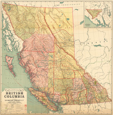
The Commercial Map of British Columbia, a small wall map dated January 1st, 1923, delineates the intricate commercial, geographical, and infrastructural elements of the province, marking a vital resource in understanding the development and expansion of this region in early 20th century Canada. Produced under the supervision of G.G. Aitken, Chief Geographer at the Land Recording Divisions, this piece illuminates the province’s connectivity through telegraph, phone, and rail lines, and offers a thorough index of post offices and a detailed table of distances connecting British Columbia to the wider world.
In the wake of World War I, Canada, and British Columbia in particular, was on a trajectory of substantial economic growth and infrastructural development. The expansion of rail, telephone, and telegraph lines as depicted in this map, underscores the province’s integration into global commerce and communication networks. Cities, villages, and notable locales are demarcated with precision, and the inclusion of government, mining, and post offices highlights the burgeoning bureaucratic and commercial landscape of the time.
The map is distinguished not only by the breadth of information it conveys but also by its organization and clarity. The right side’s exhaustive index of post offices is displayed with their geographical coordinates, attesting to the importance of communication networks in the province’s commercial and social life. On the left, a table of distances by ship, rail, and road underscores British Columbia’s connectivity within Canada and the northern U.S. and its links to cities across the globe, denoted in nautical miles, a nod to the province’s maritime heritage and global reach.
Commercial Map of British Columbia serves as a snapshot of a time and place where geographical, commercial, and social terrains were rapidly evolving. Every element, from the detailed legend marking cities, government offices, and transport lines to the carefully demarcated international and interprovincial boundaries, contributes to a comprehensive portrayal of a province in the midst of transformation. For those seeking insights into the historical progression of commerce, infrastructure, and social organization in British Columbia, this map stands as a significant and informative artifact.
Small stains on lefthand side/around border
neatline
![[ California To Alaska -- Northwest Passage ] Quivirae Regnu cum alijs versus Borea](https://storage.googleapis.com/raremaps/img/small/60083.jpg)