|
||

|

|
|

|
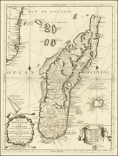
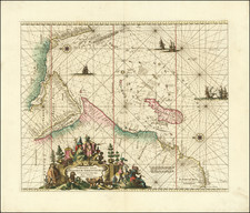
This small engraved map of Madagascar was produced in Nuremberg in 1681 by Johann Hoffmann, who adapted the earlier design of Pierre Du Val. This map is part of the Nuremberg edition of Du Val's atlas, Le Monde Terreste, ou la Geographie Universelle, which initially appeared in Paris in 1660. While various versions of this atlas existed, the Nuremberg edition, published by Hoffmann, was notable for including maps engraved by Sigismund Hipschmann.
During the 17th century, cartography became an increasingly refined discipline, with Pierre Du Val's atlases gaining recognition for their detail and accuracy. Du Val's original atlas was translated into multiple languages, including a German version by Johann Christoff Beer in 1678. However, the Nuremberg edition, overseen by Johann Hoffmann, incorporated detailed maps. While these maps drew heavily from Du Val's foundational work, there were differences, often due to the availability of sources.
The higher plate number used for this 1681 map differentiates it from its 1678 predecessor.
Pierre Duval (1618-1683) was a French geographer, cartographer, and publisher who worked in Abbeville and Paris during the seventeenth century. He was born in the former city, in northeast France, before moving to Paris. Duval was the nephew of the famous cartographer Nicolas Sanson, from whom he learned the mapmaker's art and skills. Both men worked at the royal court, having followed the royal request for artists to relocate to Paris. In addition to numerous maps and atlases, Du Val's opus also includes geography texts. He held the title of geographe ordinaire du roi from 1650 and died in 1683, when his wife and daughters took over his business.
![Atlantic Islands [Azores, Madeira, Canary and Cape Verde]](https://storage.googleapis.com/raremaps/img/small/94761.jpg)