|
||

|

|
|

|
Stock# 97850
Description
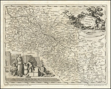
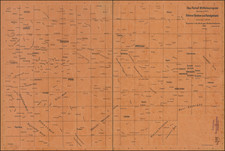
Decorative and highly detailed map of Moravia, published in Rome by Giovanni Maria Cassini.
The map offers an intricate depiction of the region, delineating its division into six distinct Circles: Znaim, Iglau, Brunn, Hradisch, Prerau, and Olmutz.The map includes numerous cities, towns, rivers, mountains, and the connecting roads that networked these larger urban settlements.
In the second half of the 18th century, Moravia was under the Habsburg Monarchy. The largest cities within each circle, notably Znaim in the Znaim Circle and Brunn in the Brunn Circle, became pivotal centers of economic and administrative activities.
Condition Description
Minor toning.
![[ Austro-Hungary ] Germany. Austrian Dominions](https://storage.googleapis.com/raremaps/img/small/102014.jpg)