|
||

|

|
|

|
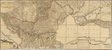
Interesting map of the territories of Hungary, Croatia, Siebenbür, Romania, Serbia, Moldova, Bukowina, Galizia, and illustrating the theater of war during the Austro-Turkish War (1787-1791).
The latter half of the 17th century and the entirety of the 18th century saw Central and Eastern Europe embroiled in a series of intense confrontations, with the Ottoman and Austrian empires often at the center. These two behemoths, representing different cultural and religious spheres, frequently clashed over control of pivotal territories and strategic strongholds.
The present map illustrates the war front during the 1787-1791 period, including the positions of troops and recently conquered regions, such as Sabac, Dresnik, Iași, Botoșani, and Dorohoi.
Historically, the confrontations between the Ottomans and Austrians were part of the larger Habsburg-Ottoman Wars, which spanned over two centuries. The battles were not just for territorial gain, but were also intertwined with the broader religious and ideological divides of Christendom and Islam. The Austrian Habsburgs, with their Catholic leanings, often garnered the support of other European powers, including the Holy Roman Empire and Polish-Lithuanian Commonwealth, in their endeavors against the Ottomans. Consequently, regions such as Hungary, Transylvania (Siebenbürgen), and Croatia became pivotal battlegrounds, as they formed the frontier between the two empires.
Delving further into the map's intricacies, the legend or "Erklärung der Zeichen" (Explanation of the Symbols) reveals a tale of military movements and territorial shifts. Icons indicating "K.k. Truppen" represent the Imperial and Royal Troops, likely those of the Austro-Hungarian Empire. "Türkische Truppen" signifies the presence or movement of Ottoman forces, while "Österreichische Grenzen" demarcates the Austrian borders. In addition, Polish and Russian frontiers are represented by "Polnische Grenzen" and "Russische Grenzen", respectively. The "Neue Eroberungen" or new conquests, as noted on the map, are indicative of territories or regions recently acquired or occupied.
Between 1787 and 1789, during the Austro-Turkish War, a series of significant battles raged in Sabac, Dresnik, Iași, Botoșani, and Dorohoi. These confrontations formed a central chapter in the longstanding rivalry between the Habsburg Monarchy and the Ottoman Empire.
Sabac, strategically located on the River Sava, was a key point of contention, given its control over essential water routes and its influence in the region. Similarly, Dresnik held strategic significance in this theater of war, indicating the dynamics of the confrontation between the two empires. The battles in Iași, Botoșani, and Dorohoi, located in the historically rich Moldavian territory, underlined the importance of this northeastern frontier in the larger ambit of the Austro-Turkish conflict.
![[ Serbia / Bosnia / Croatia ] Tabula Geographica exhibens Regnum Sclavoniae cum Syrmii Ducatu . . . MDCCXXXXV](https://storage.googleapis.com/raremaps/img/small/74757.jpg)
![[ Albania & Montenegro ] Die Noerdliche Theil des Koenigreichs Albanien mid dem Distrikte Montenegro Nro. 21](https://storage.googleapis.com/raremaps/img/small/102217.jpg)
![[ Holy Roman Empire ] Germania, Non ea tantum quae Rheno, Vistula, Danubio, mariqz Germanico Veteribus claudebatur; Sed tota illa continens quae hodie communiter Germanica lingua utitur . . .](https://storage.googleapis.com/raremaps/img/small/99236.jpg)
![(Italy and Austria) Carta geografica statistica postale dell’I.R. Monarchia Austriaca e dell’Italia [Statistical postal geographic map of the Imperial Royal Austrian Monarchy and of Italy]](https://storage.googleapis.com/raremaps/img/small/94038.jpg)