|
||

|

|
|

|
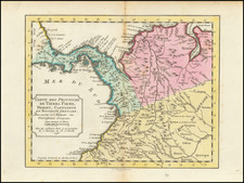
The Isthmus of Darien: Explorations of James Charles Prevost and Lionel Gisborne for a Canal Survey
Scarce map created in conjunction with a paper presented to the Royal Geographical Society in 1857, regarding British efforts to locate a practicable Canal Route across the Isthmus of Darien.
This significant cartographic work was completed by Lionel Gisborne, a British civil engineer, detailing the exploratory route of Commander James Charles Prevost across what is now the Isthmus of Panama.
Commander James Charles Prevost
James Charles Prevost was born in 1810 at Bedhampton, Hampshire, UK. He began his service with the Royal Navy in 1823, attained the rank of Lieutenant in 1835, and was promoted to Commander in 1845. Prevost served on various assignments, notably in HMS Portland on the Pacific Station in 1850 and in command of HMS Virago at Valparaiso, Chile, in 1852. By 1854, the year the map was published, he was promoted to Captain. Prevost would later be appointed the First British Commissioner for the San Juan Boundary Dispute between the United States and British Columbia/Vancouver Island. He eventually retired with the rank of Admiral in 1880 and passed away in 1891 in London, UK.
Geographical features like Prevost Island in the Gulf Islands of British Columbia and Mount Prevost near Duncan, British Columbia, are named in his honor.
Lionel Gisborne
Born to the British Consul in St. Petersburg, Lionel Gisborne was educated at Repton, in Geneva, and at Durham University. In 1842, he moved to Ireland to work on improving the navigability of the River Shannon. Gisborne's work involved deepening the river, rebuilding bridges, and constructing locks and wharves. He later worked on arterial drainage schemes in Counties Longford and Roscommon. During the famine years of 1846-47, he was involved in relief work. In 1852, he left Ireland and took up work in England and abroad. Gisborne died at the young age of 38 on January 8, 1861.
Prevost and Gisborne's Canal Efforts
In the 1850s, James Charles Prevost, then a Commander in the Royal Navy, led a series of exploratory missions across the Isthmus of Darien. Sponsored by British interests eager to establish a quicker maritime route between the Atlantic and Pacific Oceans, Prevost's mission aimed at collecting data on the feasibility of constructing a canal. He assessed topographical features, waterways, and other natural landmarks that would impact the project.
Lionel Gisborne was tasked with compiling this extensive data into a map. Despite the high level of detail and careful work, the project could not proceed to construction, primarily due to funding issues and political constraints.
Historical Context
The concept of building a canal across the Central American isthmus dates back to as early as the 16th century. However, despite many efforts from different global powers, including Spain, Britain, France, and the United States, it was not until 1914 that the Panama Canal was finally completed.
While James Charles Prevost and Lionel Gisborne did not live to see a canal built on the basis of their work, their contributions provided invaluable data that enriched the collective knowledge needed for the eventual successful construction of the Panama Canal.

![Amer. Sep. No. 71. Partie Du Mexique et de Guatemala [Oaxaca, Tabasco, Chiapa, Verapaz]](https://storage.googleapis.com/raremaps/img/small/96583.jpg)