


|
||

|

|
|

|
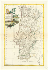
A New Map of Spain and Portugal, Divided into Their Respective Kingdoms & Provinces... 1801, drafted by John Cary in London in 1801, provides a methodical depiction of the Iberian Peninsula at the turn of the 19th century. With provinces demarcated by hand coloring, this map offers clear delineations of roads, rivers, lakes, mountains, and islands, representing the typical accuracy and clarity of English cartographic work of its time.
At the beginning of the 19th century, the Iberian Peninsula was on the brink of significant political changes, notably with the looming Napoleonic Wars that would involve both Spain and Portugal. Moreover, both countries maintained extensive colonial territories overseas. This map, in its detailed presentation, provides a snapshot of the region just before these transformative events.
John Cary (1755-1835) was a British cartographer and publisher best known for his clean engraving and distinct style which influenced the entire map industry. Born in Wiltshire, John was apprenticed to an engraver in London. He started his own business by 1782 and moved to several premises before settling at 86 St James’s Street in 1820.
Cary had several significant collaborations during his career. John Wallis and Cary diversified Cary’s business to include broader publishing projects. Brother William and John made globes together, while brother Francis participated in the company’s engraving work. Finally, geologist William Smith and Cary developed and sold geological maps, some of the first of their kind. The pair also produced a notable series of county maps starting in 1819. Cary’s atlases, of English counties and the world, were the standard texts of the early nineteenth century. He was appointed surveyor of roads to the General Post Office in 1794, which led to the New Itinerary, first published in 1798.
John trained his son, George, in engraving and George and his other son, John Jr., took over the business in 1821. It was then known as G. and J. Cary and continued in trade until 1850. The firm’s materials were then acquired by George Frederick Cruchley and then Gall and Inglis. By the time John died in 1835, Cary was the authoritative name in private map publishing and his business was a leader in the field throughout the first half of the nineteenth century.
![Islands in the Atlantic [Bermuda, Madeira, Canaries, Azores and Cape Verde Islands]](https://storage.googleapis.com/raremaps/img/small/48868.jpg)
![[Azores] Carta Reducida y General de Las Islas de los Azores . . . 1781 [east sheet]](https://storage.googleapis.com/raremaps/img/small/93245.jpg)