|
||

|

|
|

|
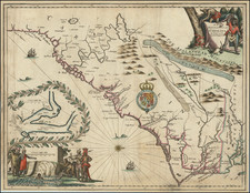
Strategic Air Chart for the Coast Between Charleston and Albermarle Sound
Produced at the tail end of the Second World War in January 1945, this map is part of a series that depicts the United States wartime radar system and infrastructure. This chart portions of South Carolina and North Carolina, specifically the Pamlico Sound, home to important naval and aeronautical infrastructure.
The main feature of this map is the useful information for aerial navigation. Importantly, it contains information on radar range, location of airfields, and other strategic military locations. This would be useful for military planners who sought to evaluate the preparedness of their country.
The reverse side of this chart contains an equally interesting key that is fundamental to understanding the various symbols, markings, and notations on the map. Given the technical nature of aeronautical charts, this information is key to effectively use this chart as intended. The back also shows how this series of charts align and connect to provide a comprehensive view of different geographic areas. The inclusion of this reference chart is a testament to the sheer scale and detail of the mapping project undertaken by the U.S. Army Air Force during World War II.
Note the text in red at the bottom, which instructed officers to update the map with new information and corrections should they find any. This was done to ensure continued accuracy of the chart, which was especially important in wartime. The fact that officers were to send these corrections directly to headquarters underscores the importance of timely and accurate information during the war.
This chart is a unique piece of domestic military history. Due to Pamlico Sound's strategic location by the Atlantic, this map was essential for strategic planning and navigation in various operations during and after World War II.

![(Second World War - The Budapest Ghetto) Budapest székesfőváros VII. ker. térképe [Map of the VII Area in the Capital City of Budapest]](https://storage.googleapis.com/raremaps/img/small/90122.jpg)