


|
||

|

|
|

|
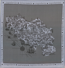
Decorative Pictorial Map of Malta
This mid-20th-century pictorial map showcases the Maltese Islands, including Malta, Gozo, and Comino. It is a vibrant and detailed representation of the archipelago, accentuating its historical and cultural heritage through illustrations and symbols.
The map is bordered by the Maltese cross and other emblems that likely signify the islands' long association with the Knights of Malta. Notable landmarks, historical events, and traditional costumes are depicted through small vignettes scattered across the map, providing insight into the local culture and history.
A detailed inset of the city of Valletta, the capital of Malta, with its grid-like street layout, is included at the bottom left, highlighting important buildings and fortifications. Various ships and boats illustrated on the surrounding Mediterranean Sea reflect Malta's storied maritime history and strategic importance.
The map's decorative border includes images of people in traditional Maltese attire and other cultural icons, such as statues and coats of arms. The inclusion of a bright sun symbol may represent the typically sunny Maltese weather, while various maritime scenes underscore the islands' relationship with the sea.
![The Monterey Peninsula California Pinto Guide Map to Fine Accommodations Restaurants Theatres Services Shops [double sided map]](https://storage.googleapis.com/raremaps/img/small/102769.jpg)