


|
||

|

|
|

|
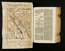
A beautiful example of Kino's seminal map of California, the map credited with ending the myth of California as an Island. Though drawn in 1702, the map was published only in 1726, in Der Neue Welt-Bott, published in Augsberg, then re-issued on a number of subsequent occasions. The map was issued at the beginning of the push to establish Jesuit Missions in California, which were first founded in 1697 and later stretch up most of the California coast. Kino's map carefully records the results of nine journeys he made in northwestern Mexico and along the Colorado River. On one of these, sighting only land to the west from an elevation near the head of the Colorado River, Kino declared unequivocally that California was part of the North American continent. Although progressive European Cartographers adopted Kino's geography, the California-as-an-island myth was not fully dispelled until 1746 when another Jesuit, Father Consag, provided conclusive proof. E.J. Burrus, S.J. Kino and the Cartography of Northwestern New Spain, pl. XII, pp. 47-50; D.B. Polk, The Island of California, pp. 295-302; not in Wheat and Wagner. The second of two Kino maps, the first is dated 1701 and published by Insel in 1705 and after.