|
||

|

|
|

|
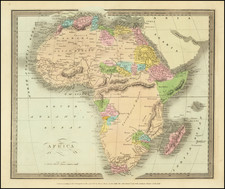
Colonialism Takes Shape.
Africa Published Under the Directions of the Committee of General Literature & Education, dated approximately 1864 and issued in London, delineates the African continent's colonial territories and indigenous groups. Distinguished by distinct color codings, this map documents the presence of various European powers, alongside the notable indigenous tribes, offering a snapshot of the geopolitical layout of 19th-century Africa. Regions such as the Orange River Free State, Transvaal Republic, Caffraria, and others, including Abyssinia and Sierra Leone, are notably portrayed.
During the 19th century, European powers increased their engagement with the African continent. This map, with its distinct colorations like Spanish blue and French orange, serves as a representation of these interactions and the subsequent territorial divisions. In parallel, the map provides an account of indigenous groups, highlighting entities such as the Moors, Tuaricks, Tebu, and the Fellatah States.
Moreover, the inclusion of regions labeled as "Negro populations but little known or under petty chiefs" and "Gallas & Somauli independent nomades of East Africa" offers a view into the limited European knowledge of certain parts of the continent. Overall, this map stands as a historical record, tracing the contours of European colonial interest while also acknowledging the diversity and presence of indigenous African communities.
Dating is based on another map, of North America, from the same group.
Rarity
We find no examples of this (or any) edition in OCLC. In 2021, Swann sold a substantially different 1895 edition.
The Proceedings of the RGS records an edition of 1879. There were probably others into the 20th century.
![Affrika třetj djl okrsslku zemského [Czech Language Edition]](https://storage.googleapis.com/raremaps/img/small/93470.jpg)