|
||

|

|
|

|
Stock# 97522
Description
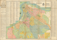
Lively pictorial map of Yugoslavia, providing a colorful and illustrative representation of the country as it existed in the mid-20th century.
The map is populated with numerous pictorial illustrations that symbolize cultural landmarks, historical sites, and economic activities of the region.
On the verso are images and text panels provide additional context, each detailing specific aspects of Yugoslavian life, heritage, and tourism.
![(Tyrol, etc.) Tirolensis Comitatus: Seu partis Rhetiae Alpestris insignis descriptio Ch[orog]aphica [and] Carniolae Chaziolae que Ducatus Nec Non et Goritiae Comitatus](https://storage.googleapis.com/raremaps/img/small/75387.jpg)