|
||

|

|
|

|
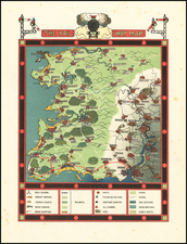
This colorful and informative map, titled "The National Savings Picture Map of the Continent of Europe," offers a comprehensive portrayal of Europe, emphasizing its geography, natural features, historical events, famous buildings, great figures, and key industries. Designed as an educational tool, the map is bordered by detailed facts about each of the 29 European countries, including their size, population, and currency. The central map is filled with vibrant illustrations representing various elements unique to each country. For instance, landmarks, historical events, and notable figures are depicted with charming illustrations that capture the essence of each region. This visual richness provides an engaging way to learn about the continent's diverse cultural and historical landscape.
A key to symbols, prominently displayed in a decorative frame, explains the icons used to denote different industries and natural resources, such as heavy industry, coal, iron, oil, lead, tin, copper, timber (both coniferous and deciduous), palm, wheat, maize, flax, oranges, lemons, apples, olives, dairy produce, cattle, sheep, pigs, wines, tobacco, and potatoes. This allows viewers to easily understand the economic activities prevalent in different parts of Europe.
Surrounding the map are facts about each country, including Sweden, Denmark, Russia, Danzig, Finland, Poland, Austria, Belgium, Norway, and others. These facts provide valuable context about each nation's geography, governance, and demographics, enhancing the map's educational value. The top left section of the map features a statement emphasizing the importance of studying this map for all citizens, particularly the youth of Great Britain, to foster a better understanding of their European neighbors: "The whole should be studied by all citizens, and growing citizens of GREAT BRITAIN, for the better understanding of our neighbors."
The experience of the United Kingdom and its inhabitants during the Second World War was a harrowing one. Threats of indiscriminate bombings, possible invasion, and starvation by blockade were experienced by many thousands, and at times the prospects for victory seemed bleak. However, the U.K. and her allies eventually persevered, and efforts to reintegrate the British Isles, and indeed, all of Europe, began shortly after the conclusion of the war.
This map is an excellent example of such an endeavor, issued collectively by the National Savings Committees of London, Edinburgh, and Belfast. Interestingly, the image depicts national borders from 1938, reflecting the difficulty in updating that information due to uncertainty surrounding the postwar political situation. Dozens of vignettes showcase agricultural and industrial exports, prominent historic figures, and significant scientific or cultural contributions from each European country. Major cities are identified with custom illustrations highlighting local architecture.
The map is surrounded by a border listing each nation’s flag, along with relevant facts and figures like population, size, currency, and capital. Germany is notably included as an apparent equal. The map was drawn by H. Charles Paine in 1945 and printed in Bristol by Mardon, Son, & Hall Ltd. This colorful pictorial map illustrates the natural resources, historic figures, and important landmarks for each country. A legend is included at the top right to identify each of the resources, such as coal, oil, timber, wheat, oranges, cattle, wine, and tobacco. An inset in the Norwegian Sea lists which counties in the British Isles are known for each resource. The border of the map features the flags of each country along with some basic facts, as well as the portraits of famous people from the British Isles, such as William Shakespeare, Sir Isaac Newton, and Florence Nightingale.
Published at the end of World War II, the map was issued jointly by the National Savings Committee, the Scottish Savings Committee, and the Ulster Savings Committee to offer a "better understanding of our neighbours." The title cartouche also encourages citizens to "save for the future," which was a common motto used by the National Savings Movement to encourage individuals to save their money in government-backed products to help finance the government. This map serves as a beautifully crafted piece of visual art and a rich educational resource, effectively combining geographical information with historical and cultural elements, making it an invaluable tool for learning about Europe in the mid-20th century.
![[ Celtic Europe ] Europam, Sive Celticam Veterem . . .](https://storage.googleapis.com/raremaps/img/small/81944.jpg)
![(Hannibal Crosses the Alps) Expeditiones Hannibalis per Hispaniam, Galliam, Italiam, Africam &c. ex Plutarcho &c. . . . [The expeditions of Hannibal through Spain, Gaul, Italy, Africa, &c. from Plutarch &c. . . .]](https://storage.googleapis.com/raremaps/img/small/85241.jpg)