|
||

|

|
|

|
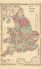
The Grand Southern Tour of England by M. Phillips, Civil Engineer & Surveyor, published by Jonathan Hebner in circa 1837, provides a detailed representation of southern England, encompassing counties from Herefordshire to Somersetshire and from Suffolk to Kent. Endorsed by notable figures such as Her Majesty the Queen and His Royal Highness The Prince Regent, this map offers both geographical and social insights into the era.
The 1830s witnessed gradual advancements in travel infrastructure, primarily with the extension of railway networks. These developments facilitated a growing interest in domestic travel and a broader understanding of one's own country. In this context, The Grand Southern Tour of England emerges as a reflection of its time, catering to the interests of those exploring southern England.
Furthermore, the map's patronage by esteemed institutions and members of the Royal Family highlights its significance in the period. The inclusion of counties such as Herefordshire, Suffolk, Kent, and Somersetshire provides comprehensive coverage of southern England, reflecting the importance of these regions during the 19th century. Through its detailed portrayal, the map stands as a valuable document of mid-19th-century geographical knowledge and societal dynamics.
State
State 6 (of 6): the title now refers to Queen Victoria; the date has been erased, and the reference to the map being a second edition.