|
||

|

|
|

|
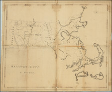
A Conflagration of Whale Oil.
A Great Nantucket Rarity, Illustrating the Town's Most Transformative Event of the 19th Century.
Map of that Section of the Town of Nantucket, which was destroyed by fire on the night of the 13th July, 1846, executed by Samuel Haynes Jenks, Jr. (1819-1858) and lithographed by Bufford & Cos. of Boston, offers a detailed account of the significant fire's impact on Nantucket's urban fabric. Through a systematic use of hachures and notations, the map presents a clear distinction between brick and wood buildings, indicating those that were consumed by the fire and those few that remained standing. Additionally, it enumerates key structures such as W.H. Geary's Hat Store, the origin of the fire, along with prominent establishments like the Athenaeum and Washington Hall.
In 1846, Nantucket was undergoing economic and social transitions, having once been a whaling capital. This fire affected a large part of the town center, consuming major establishments, including financial institutions like the Pacific Bank, cultural centers, and essential offices that played roles in the town's communication and commerce.
The Great Fire of July 13, 1846
The Nantucket fire of 1846 was one of the most devastating events in the history of Nantucket Island. On July 13, 1846, a fire ignited at the hat shop of William M. Geary on Main Street. Fanned by strong winds and aided by the many casks of whale oil in warehouses and the wooden structures prevalent in the town, the fire quickly spread, consuming over 300 buildings, including homes, businesses, and warehouses. This calamity resulted in a major transformation of Nantucket's architecture and layout as the town rebuilt. The fire was a significant blow to the island's declining whaling industry and marked a turning point in Nantucket's economic and cultural history.
Nantucket's reliance on wooden architecture, typical for the period, exacerbated the vulnerability of its buildings to fire, a fact underscored by the map's emphasis on material types. The map also marks reservoirs of water, highlighting the town's resources, or perhaps the lack thereof, to combat such a disaster. At the intersection of Main and Centre Streets, a reservoir looks to have played an important role in protecting the buildings to the southeast; however, two blocks to the east, two reservoirs are completely surrounded by burned buildings.
While this event marked a dark chapter in Nantucket's history, the town's resilience is evidenced in its subsequent recovery and continued growth, making this map an important documentation of a transformative moment in its evolution.
Manuscript Amendments?
A total of six buildings, most near the intersection of Pearl and Centre Streets, have been marked with ink hachures in a neat hand. This is evidently an attempt to note burned buildings that were erroneously left out of the first draft of the lithograph. In the Leventhal's example, this hachuring seems to be rendered in light lithography, but it is hard to say definitively.
Rarity
OCLC records two examples, at the BPL Norman B. Leventhal Map Center, and Mass. Historical. To this, we can add Nantucket Historical Society.