|
||

|

|
|

|
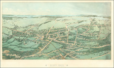
Bird's eye view of the towns along the streetcar line (and connecting lines) between Worcester and Boston's Park Square, published a year after service commenced in 1903. With the landscape rendered in full color and a genteel crowd pictured in a car, the map emphasizes the beauty and comfort of the route. While the street railway was a slower ride than the Boston and Albany Railroad, running on a similar route, the trolley fare from Boston to Worcester was 45 cents to the railroad's one dollar and the line offered more local service, both a boon to commuters. Transfers were free in Boston and Worcester. The future branch to Natick, to which the railway received rights in 1907, is shown. Buses began to replace the trolleys in the 1920s, with a few of the spur lines being phased out completely.
Today, many trails are being developed and maintained along former trolley routes, such as the Boston Worcester Air Line Trail through Westborough, Northborough, and Shrewsbury and the Ashland Trolley Brook Trail.
Rarity
This map is quite rare on the market.
"An Interesting Form of Street Railway Advertising." The Street railway journal v. 24 July-Dec.1904. McGraw Pub. Co.
"Another Move in Interruban Matters in Boston." The Street railway journal v. 30 July-Dec. 1907. McGraw Pub. Co.
![[Salem, Massachusetts] Salem Eine Stadt im Engellandischen America, in der Grafschafft Essex, welche von den Engellandern 1629 erbauet worden, und 2 Havfen hat einen fur den Sommer, und einen fur den Winter](https://storage.googleapis.com/raremaps/img/small/70175.jpg)