


|
||

|

|
|

|
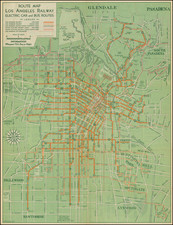
Intricate street map of Los Angeles from the early 1940s. Many roads, highways, and railroads are illustrated. The map names all the depicted streets and includes some notable locations like the LA Coliseum of Union Depot. The locations of Bekins storage (publishers of this map) are bolded and written larger than anything else. The map's title block also features a list of their locations across LA. The map itself is done with an alpha-numeric grid so someone can reference a location based on the indexed list of streets. The names of neighborhoods are lightly dotted across the map.
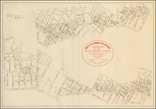
The verso features a long, alphabetized list of streets with coordinates that relate to their location on the previous map. Apparently, Los Angeles did not have any streets that started with "X" in the early 1940s. This section also features a series of advertisements for Bekins Moving and Storage services. The company proudly offers local and nationwide moving services where they utilize trucks and trains to transport possessions across the country. A small inset map of the West shows the available van or train routes one can use to move. The other advertisement is about the storage services the company offers. The main draw here is the novelty of cold storage vaults for furs, mothproofing and rug cleaning options (both in home and at a location), and the new and used furniture salesroom.
![[Official Route Map Los Angeles]](https://storage.googleapis.com/raremaps/img/small/70212.jpg)
![[1874 Los Angeles Real Estate Indenture and supporting documents]](https://storage.googleapis.com/raremaps/img/small/82641.jpg)