|
||

|

|
|

|
The Rare Second State.
Schilder Traces Only Five Examples.
"A balanced composition and elegant ornamentation make this world map one of the small masterpieces of the seventeenth century." - Schilder (MCN VI, page 87)
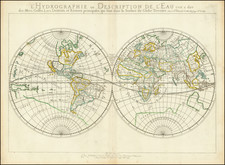
This is one of the finest and most famous world maps to appear in an atlas during the Golden Age of Dutch cartography. It was prepared by Willem Janszoon Blaeu while he was working on his four-sheet world map that was also published in 1606. Throughout the latter part of the first decade of the 17th century, Blaeu prepared a set of world and continents maps in both wall map and folio format.
The map's rectangular shape and grid of latitude and longitude lines reflect Willem Janszoon Blaeu's use of Gerard Mercator's projection, which was first introduced in 1569. Blaeu's map is essentially a reduced-size version of his four-sheet wall map of 1606-7, with nearly identical geographical information. As is characteristic of the Mercator projection, the sizes and shapes of land masses in the polar regions are greatly exaggerated.
The map is dedicated to Cornelis Pietersz. Hooft (1547-1626), an important Amsterdam-based merchant and statesman. In 1578, Hooft had married Anna Jacobsdr Blaeu. Anna was the cousin of Willem Jansz. Blaeu and Hooft ended up providing temporary work to Willem through this relationship.
This became the Blaeu firm's standard world map in their atlases until 1662, when Joan Blaeu added a double-hemisphere map of the world and later a double-hemisphere polar projection, which was apparently not issued during his lifetime, but was later issued by Valck. The map was so successful from a decorative standpoint that the market remained strong for it long after its cartography had been surpassed by other offerings.
The Decorative Elements
Schilder notes of the decorative borders:
The decorative borders of the world map were not derived from artists' designs specially ordered by the publisher. On the contrary, Blaeu had a compilation made from various series of prints which had already been published by famous Dutch artists at the end of the sixteenth century (Map 1, ill. 3; for a detailed illustrated discussion see Schilder (1993a), Facsimile 7). A balanced composition and elegant ornamentation make this world map one of the small masterpieces of the seventeenth century.
Although the second state bears the signature of engraver Josua van den Ende, it is likely that he engraved only the cartography and that someone else was responsible for the decoration (MCN, page 86).
The top border features the Septem Planeta with illustrations of the planet gods of classical mythology in seven oval medallions: the moon goddess Luna represented as the goddess of the hunt; Mercurius depicted as the god of trade; Venus portrayed as the goddess of love; the sun god Sol; Mars symbolized as the god of war; the King of gods, Iupiter, accompanied by his thunderbolts; and Saturnus characterized as the god of growth.
These seven figures of gods are juxtaposed by the lower border in the Septem Mirabilia Mundi, where seven medallions encapsulate depictions of the Seven Wonders of the Ancient World: Murus Babyloniæ, the wall of Babylon; Colossus, the twering statue at the harbor entrance of Rhodes; Pyramides, the Egyptian pyramids; Mausoleum, the tomb of King Mausolos in Halicarnassus; Diane Templum, the Temple of Artemis at Ephesus; Iupiter Olympicus, the statue of Zeus created by Phidias at Olympia; and Pharos, the lighthouse of Alexandria.
The side borders are segmented into four rectangular sections, with the four elements (Quatuor Elementa) on the left and the four seasons (Quatuor Anni Tempestates) on the right.
States of the Map:
The present example is state 5 of the map. The states can be determined as follows:
- State 1. The image does not include the signature "Ja. vanden Ende sculpsit." to the lower left of the South Pole projection. Shirley says "possibly a proof".
- State 1b? The mountains in "Terra del Fogo" are now engraved with hachuring, not the simple faint outlines of the previous state. This is an unconfirmed state but is supported by reproductions in MCN VI of both the Newberry and RGS first states (second variant), compared with the RMG example and an example we have seen privately (first variant).
- State 2. With the signature of Josua van den Ende: "Ja. vanden Ende sculpsit"
- State 3. As state 2, but Terra del Fuego is now an island and Fretum le Maire has been added. Probably issued in 1617, as a companion map of Europe bears this date. The plate wore rather quickly up to state 2, and in state 3, it has been substantially cleaned up and retouched, with many areas of hachuring burnished out and carefully reworked.
- State 4: "Gul. Jansonius 1606" removed and replaced with "Guil. Blaeuw". "Gulielmus Janssonius" replaced with "Gulielmo Blaeuw"
- State 5: Confusingly, this final state, unrecorded by Shirley, adds back the connection between Terra del Fuego and the Southern Continent and some of the coastline erased in the third state.
Rarity
Schilder (VI, page 87) records the following five examples of the second state: Darmstadt, Hessische Landes- und Hochschulbibliothek (K W 5). Dresden, Sächsische Landesbibliothek (A 100 [formerly: Tab. geogr. A 260]). London, The British Library (Maps 920 [262]; map only). Schwerin, Landesbibliothek Mecklenburg-Vorpommern (N. 2). Stuttgart, Württembergische Landesbibliothek (bound in Ortelius's Parergon; right half is missing).
Shirley (255) "Copies of states 1-3 are rare."
Willem Janszoon Blaeu (1571-1638) was a prominent Dutch geographer and publisher. Born the son of a herring merchant, Blaeu chose not fish but mathematics and astronomy for his focus. He studied with the famous Danish astronomer Tycho Brahe, with whom he honed his instrument and globe making skills. Blaeu set up shop in Amsterdam, where he sold instruments and globes, published maps, and edited the works of intellectuals like Descartes and Hugo Grotius. In 1635, he released his atlas, Theatrum Orbis Terrarum, sive, Atlas novus.
Willem died in 1638. He had two sons, Cornelis (1610-1648) and Joan (1596-1673). Joan trained as a lawyer, but joined his father’s business rather than practice. After his father’s death, the brothers took over their father’s shop and Joan took on his work as hydrographer to the Dutch East India Company. Later in life, Joan would modify and greatly expand his father’s Atlas novus, eventually releasing his masterpiece, the Atlas maior, between 1662 and 1672.
![[Medieval World Map] Das ist die mapa mudi und alle Land un Kungkreich wie sie ligend in der ganze Welt](https://storage.googleapis.com/raremaps/img/small/102357.jpg)
![[The centre of this Slider is to be placed by a Thread or Pin over the centre of the respective Planisphere for any Operation]](https://storage.googleapis.com/raremaps/img/small/65557.jpg)