|
||

|

|
|

|
Stock# 97406
Description
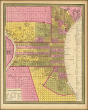
Early Philadelphia Streets
A hand-drawn map of a section of Old Town Philadelphia. The map shows the intersection between Fitler and Second Street, likely not the second street of Philidelphia today. The map also shows the Black Horse Lane, part of the German Town Road Frankford Road (now Frankford Avenue in Philidelphia).
The map includes a Brick House, Stone House, Well and Barn on Fitler Street.
Fitler intersects with Black Horse Land running from Germantown Road to the Frankford Road.
The street would appear to be in Torresdale, also formerly known as Torrisdale, is a neighborhood in the Far Northeast section of Philadelphia.
Fitler Street is likely named after Edwin H. Fitler, a popular mayor of Philadelphia from 1887 to 1891.
Condition Description
Some tearing, most not affecting image. Toning throughout as pictured. Foxing on left.
Reference
https://www.ushistory.org/philadelphia/formerstreets.htm