|
||

|

|
|

|
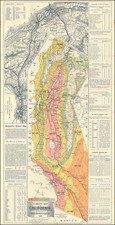
Rare map of the High Sierras and Whitney Portal area, prepared by the Hayden Map Company, covering the area along Highway 6-395 from Olancha to Independence, with a large inset map of the Lone Pine Business District.
Focused on local recreation, tourism, hunting, fishing and camping in the High Sierras, this is perhaps the best regional map published in this period, highlighting the important tourist locations, such as Whitney Pack Trains, Golden Trout Camp, Bob White's Camp, etc. The map shows in a pictorial style the mountains, rivers, lakes and valleys of the region. Several early airplane landing fields and strips are noted.
The inset of Lone Pine shows a thriving community, with a Ball Park, Rodeo Grounds and infrastructure.
The map is surrounded by interesting local advertising.
The Hayden Map Company was founded in the 1930s by Emmet Hayden. In 1927, Emmet Hayden procured a lease in the Inyo National Forest, where he built a four bedroom log cabin which is the Mammoth Lakes Museum today. Emmet was an Engineer, Surveyor, and Mapmaker by training. He put Mammoth Lakes on his 1934 map, titled "A Circle of Enchantment." Originally, the Hayden Map Company did sub-division work in the Los Angeles area. After moving to Mammoth Lakes for his summer residence, he had the idea of being a hunting and fishing guide, which became the Hayden Map Company. The two earliest maps were the "Three Flags Highway" and "The Circle of Enchantment."
Rarity
This is the first example of the map we have ever seen.
![[ Upper California ] Map of the Californias By T.J. Farnham](https://storage.googleapis.com/raremaps/img/small/99592.jpg)