|
||

|

|
|

|
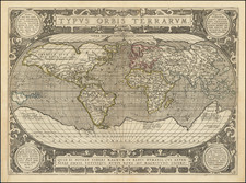
Detailed map of the world on Mercator's projection, published in London by Emanuel Bowen.
Shows an unknown eastern coast of Australia, incomplete New Zealand, and incomplete northwest coast of America.
One of the most interesting features is the appearance of De Gama Land to the east of Japan. Includes a mythical De Gama's Land, east of Yeso and Japan. In the early 17th century rumors began to circulate that a Spanish ship, traveling east from the Philippines to Mexico, had been blown off course and discovered a land in the north rich in gold and silver as all unreachable lands were. In later versions, the ship became Portuguese with a captain named Juan de Gama. In some geographer's minds, de Gama's land and Ezo were one and the same. In others, Ezo was a part of the Asian mainland and de Gama's land was a separate land in the North Pacific.
The Sea of Japan is labeled as the Sea of Corea (Korea) and the Sea of Okhotsk as the Sea of Kamchatka.
In the 1730s and 1740s, De Gama Land was a source of intellectual debate, not as to its existence, but its exact location, with such important explorers as De L'Isle, de la Croyere and Chiricow, each opining as to its location.
Decorative cartouche and compass roses. Numerous rhumb lines.
Emanuel Bowen (1694?-1767) was a British engraver and print seller. He was most well-known for his atlases and county maps. Although he died in poverty, he was widely acknowledged for his expertise and was appointed as mapmaker to both George II of England and Louis XV of France. His business was carried on by his son, Thomas Bowen. He also trained many apprentices, two of whom became prominent mapmakers, Thomas Kitchin and Thomas Jeffreys.
![[ Mapping The World's Telegraph Lines ] Planisphere Terrestre Indiquant Les Lignes Modernes de grande Communication par terre et par me Chemins De Fer - Paquebots-Telegraphie Electrique. . . . 1878](https://storage.googleapis.com/raremaps/img/small/98800.jpg)
![[Cook's Circumnavigation of the World] Carte Generale Offrant Les Decouvertes Faites Par Le Capitaine Jacques Cook . . . .Par Henry Robert, Lieutenant de la Marine du Roi](https://storage.googleapis.com/raremaps/img/small/70382.jpg)