|
||

|

|
|

|
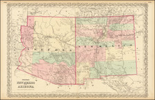
Railroad and County Map of New Mexico by George F. Cram, engraved and published in Chicago in 1886, offers a comprehensive representation of New Mexico's transportation networks and administrative divisions during the late 19th century. Notably delineated are the emerging railroads, both completed and unfinished, as well as the intricate system of county seats, post offices, small towns, and the state capitol. Alongside these features, the map draws a distinction between "confirmed" and "unconfirmed" land grants, casting a spotlight on the complexities of land ownership during this pivotal period in American history.
The late 19th century was a transformative time for New Mexico and the wider American West. The region was undergoing monumental changes with the advent and rapid spread of the railroad system. The emergence of new transportation networks marked an era of increased mobility, economic growth, and societal evolution. The railroads were not just pathways for commerce and migration; they reshaped the landscapes and destinies of territories, forging connections between previously isolated communities.
Moreover, the delineation of "confirmed" and "unconfirmed" grants on the map alludes to the fraught nature of land tenure in New Mexico during this time. As the United States expanded westward, tensions arose over land rights, especially between indigenous communities and settlers. The use of yellow to mark reservations and the distinction of red shading for confirmed grants highlights the push and pull over territorial dominion, capturing the legal intricacies and cultural shifts associated with the American West's annexation.
In addition to territorial markers, the map's careful detailing of administrative symbols — distinguishing between post offices, county seats, and the state capitol — serves as a testament to the infrastructural growth and the deepening bureaucratization of the region. Such demarcations underscore New Mexico's march towards statehood and the establishment of governance structures.
In conclusion, Cram's 1886 map of New Mexico is more than a geographical depiction; it's a chronicle of a time and place in transition. It stands as an invaluable resource for understanding the profound shifts — in transportation, governance, and territorial delineations — that characterized the American West during the waning years of the 19th century.
George F. Cram (1842-1928), or George Franklin Cram, was an American mapmaker and businessman. During the Civil War, Cram served under General William Tecumseh Sherman and participated in his March to the Sea. His letters of that time are now important sources for historians of the Civil War. In 1867, Cram and his uncle, Rufus Blanchard, began the company known by their names in Evanston, Illinois.
Two years later, Cram became sole proprietor and the company was henceforth known as George F. Cram Co. Specializing in atlases, Cram was one of the first American companies to publish a world atlas. One of their most famous products was the Unrivaled Atlas of the World, in print from the 1880s to the 1950s.
Cram died in 1928, seven years after he had merged the business with that of a customer, E.A. Peterson. The new company still bore Cram’s name. Four years later, the Cram Company began to make globes, a branch of the business that would continue until 2012, when the company ceased to operate. For the final several decades of the company’s existence it was controlled by the Douthit family, who sold it just before the company was shuttered.
![[Arizona below New Mexico] Mexique d'apres le grand Atlas Dresse Par A.H. Dufour Grave par ch Dyonet Pubie par A. Le Chevalier . . . 1863](https://storage.googleapis.com/raremaps/img/small/64395.jpg)