|
||

|

|
|

|
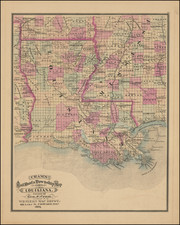
Gray's New Map of Louisiana by Frank A. Gray, published in Philadelphia in 1881, offers a comprehensive representation of Louisiana during a pivotal period of its history. This map, colored distinctively by parishes, meticulously illustrates a myriad of details, ranging from established towns to the emerging railroad networks, swamps, Post Offices, islands, and sand bars. Large insets, providing detailed renderings of the City of New Orleans and the Passes of the Mississippi River, accentuate the map's depth and breadth.
The latter half of the 19th century was a transformative time for Louisiana. Following the tumult of the Civil War and Reconstruction, Louisiana was undergoing significant changes in its socio-economic and political landscapes. The state was striving to rebuild and redefine its identity amidst the wider currents of American expansion, industrialization, and urbanization. This map offers a snapshot of Louisiana in this transformative epoch, serving as a testament to the resilience and adaptability of its people.
Transportation emerges as a central theme of Gray's New Map. The railroads, often heralded as the arteries of the 19th-century American economy, are prominently displayed, interweaving between towns and parishes. These lines not only signified trade and commerce but also represented a rapidly changing socio-cultural landscape, uniting disparate regions and ushering in an age of unparalleled connectivity.
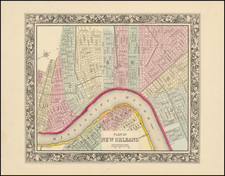
The insets, especially that of the City of New Orleans, provide focused insights into the urban hubs of Louisiana. As one of the premier ports and cultural melting pots in the United States, New Orleans, at this time, was a confluence of diverse traditions, commerce, and music. The detailed rendering of the city captures its essence, signifying its importance in the broader Louisiana and Mississippi River narratives.
Furthermore, the inset detailing the Passes of the Mississippi River underscores the strategic and commercial significance of this mighty river. The Mississippi, a vital conduit for trade, was the lifeblood for numerous cities and towns, with its passes serving as gateways to the Gulf of Mexico and beyond. This feature, crucial for navigation and commerce, further amplifies the map's value as a document of Louisiana's intricate relationship with its natural geography.
In totality, Gray's New Map of Louisiana stands as a monument to the complexity and dynamism of Louisiana in the 1880s. It not only offers geographical details but also provides a layered narrative of a state in transition, capturing the intersections of nature, culture, and commerce.
O. W. Gray was a publishing firm based in Philadelphia. Later, they published as O. W. Gray & Son. They published atlases in the late nineteenth century. Gray's National Atlas was one of the most successful commercial ventures of the 1870s and one of the last to employ hand coloring on maps.
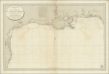
![[Florida to New Orleans] The North Coast of the Gulf of Mexico from St. Marks to Galveston . . . 1842](https://storage.googleapis.com/raremaps/img/small/83469.jpg)