|
||

|

|
|

|
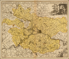
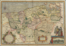
Fantastic Set of French-Executed Hand-Drawn Coal Mining Maps from the Nord Pas de Calais Basin.
Beautifully set of nine hand-drawn maps of coal mines in northeastern France, made by a French engineer and housed in two custom green morocco slipcases.
The maps show cross-sections of mines, plans of various lots (or "actions"), and concessions in different regions. Different types of pumps, pressure-relief systems, vapor release points, and other features are all shown. Long veins are followed and named, and the map presents a wealth of information regarding the historical mining activity here. The maps even look back on previous generations of mines, with "ancient explorations" noted. The maps show various cities on the French-Belgian border, including Mons and Quaregnon.
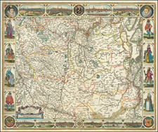
The Nord-Pas-de-Calais mining region, located in northern France, was once the heartland of the country's coal mining industry. Rich in anthracite and bituminous coal, the area became a focal point for industrial development in the 19th and early 20th centuries, attracting a diverse workforce that included local French laborers as well as immigrants from countries like Poland and Italy. The extensive network of mines, characterized by its deep shafts and intricate tunnel systems, not only fueled France's industrial revolution but also had a profound impact on the region's social and cultural landscape. Remarkably, coal was first discovered in the region as early as 1660, and the first mining pit was dug in 1692, laying the groundwork for the area's future as a mining powerhouse.
The nine maps are titled:
- Plan des Concessions de la Pucelette . . . du Grand-Moulin, sur Semmape et du fief du Flenu
- Concession de la Pucelette . . . Arrondissement de Mons Department de Semmape
- Mines de houille de vingt actions Fief du Flenu . . . Projection horizontale de l'exploitation faite dans la dure Veine
- Mines de houille de vingt Actions Fief du Fleine . . . Projection horizontale de l'exploitation faite dans la veine de la petite Bechee
- Mines de Houille de vingt Actions Fief de Flenu . . . Projection horizontale de l'exploitation faite dans la veine de la grande Bechee
- Concession du Grand Moulin sur Semmape | Mines de Houille de Vingt-Actions sur le Fleuve
- [Lacking]
- Exploitation de la veine de la Pucelette
- Mine de Houille de Vingt action Fief du Flenu sur Quaregnon et Semmape . . . Projection Horizontale de l'Exploitation faite dans la dure veine
- Mines de houille de vingt actions Exploitation faite dans les veine de la Petite et Grande Bechee
Provenance
The maps come from a collection owned by Romain-Joseph de Brigode-Kemlandt, Baron of the Empire (1775 - 1854), who was a deputy from the Nord in the Assemblée National and mayor of Annappes. He married the granddaughter of the Marquis de Lafayette, Célestine Louise Henriette de Fay de La Tour-Maubourg. It is his initial "K" that appears on the green slipcase.
![[ Arras ] Atrebatum, fertilissimae Artesiae Urbs primaria, elegantissimo situ . . .](https://storage.googleapis.com/raremaps/img/small/74979.jpg)