


|
||

|

|
|

|
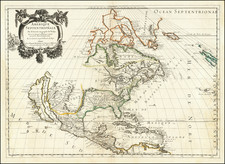
The Second Large Sanson Map of North America
First state of the Sanson-Mariette map of North America, first issued in 1669.
This atlas map was produced by Guillaume Sanson and Pierre Mariette after the death of Guillaume's father, Nicolas, in 1667. The map is drawn on the sinusoidal projection, which is also called the Sanson-Flamstead projection.
The ma is a reduced-size copy of Nicolas Sanson's four-sheet wall map of North America, published in 1666, which survives in only two known examples (one dated 1666, one dated 1667). However, this map has changes as compared to its wall-map predecessor. It includes C. Blanco in California and adds R. de Nort, or the Hudson River. The shape of Iceland and the British Isles are also new.
The continent is tightly framed, with only a sliver of northern South America visible. California is shown as an island. Its shape is influenced by the Foxe depiction of 1635 and is also called the second Sanson model.
The northwest of the continent is empty and obscured by the decorative cartouche. In the northeast, Greenland appears connected to North America. New North Wales seemingly floats in northern Hudson’s Bay, giving way to another coastline, New Denmark. This trails southwest-ward to a Mer Glaciale—the dream of a Northwest Passage is alive and well on this map. Much of this configuration is inspired by Thomas Button’s trip to Hudson’s Bay in 1612-3, when he named Port Nelson and Ne Ultra. Button’s Bay is named for him. Luke Foxe, on another voyage seeking the passage in 1631, named the area New Wales.
The center of the continent is dominated by Quivira. This toponym refers to the Seven Cities of Gold sought by the Spanish explorer Francisco Vasquez de Coronado in 1541. In 1539, Coronado wandered over what today is Arizona and New Mexico, eventually heading to what is now Kansas to find the supposedly rich city of Quivira. Although he never found the cities or the gold, the name stuck on maps of southwest North America, wandering from east to west.
States and Rarity
There are two states of this map, which featured in Les Cartes Génerales de toutes les parties du Monde.
- Dated 1669.
- Dated 1690. Has the addition of North Pacific chimeric islands and the words, “N. Yorq aut” and “N. YORC” in the title.
This Guillaume Sanson atlas map of North America is much scarcer than that of his father (1650).
The son of famous French cartographer Nicolas Sanson, Guillaume (1633-1703) carried on his father's work. Like his sire, he was a court geographer to Louis XIV. He often worked in partnership with another prominent cartographer of the time, Hubert Jaillot.


![[Revolutionary War Plans of New York, Boston, Charleston, Delaware River to Philadelphia & Havana] Various Plans and Draughts of Cities, Towns, Harbours &c . . .](https://storage.googleapis.com/raremaps/img/small/83450.jpg)