


|
||

|

|
|

|
Stock# 97110
Description
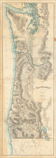
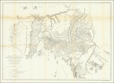
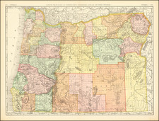
The Most Detailed Map of Oregon Published in the 1880s
Scarce and highly detailed general land office map of Oregon, tracking the growth of the State.
The map highlights to growth expansion of formal settlements of Indian Tribes in the State, the expansion of the township surveys and growing knowledge of topographical features east of the Cascade Mountains.
Includes tremendous topographical and geographical detail, including up to date state surveys, Indian and Military Reservations, early railroad lines, post offices, forts, towns, rivers, roads, lakes, mountains, etc.
Perhaps the best large format map of Oregon of the period.
Condition Description
Soiling at right side from an earlier binding.
![[WWII War Bonds] As](https://storage.googleapis.com/raremaps/img/small/63461.jpg)

![[ California To Alaska -- Northwest Passage ] Quivirae Regnu cum alijs versus Borea](https://storage.googleapis.com/raremaps/img/small/60083.jpg)