This item has been sold, but you can enter your email address to be notified if another example becomes available.


|
||

|

|
|

|
Stock# 9710
Description
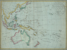
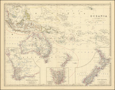
Striking and detailed mapping of the Oceana and the Pacific Ocean, with fascinating overlay style. The basic map is the Pacific Rim, from Alaska to Tierra del Fuego and Kamtschatka to SE Asia. All the islands of the Pacific and Oceana are shown. In the upper right corner is a large inset of the Sandwich or Hawaiian Islands, with a set of notes on the census of 1849 and other details. A nice set of remarks and explanations appear. In the bottom left corner is an inset map of the Antarctic Continent, with a set of remarks. The map is colored by colonies and possessions, including British, Dutch, Spanish, Portuguese and Native. A terrific regional map.