


|
||

|

|
|

|
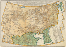
Krusenstern Maps Japan and the East Coast of Korea -- First Mapping of the Osumi Strait
A fine depiction of Japan and the east coast of Korea, drawn from the German edition of Atlas to accompany the account of Krusenstern's Voyage Round the World in the Years 1803, 1804, 1805 & 1806.
Among other milestones on the expedition, Krusenstern became the first European mapmaker to map Japan's Osumi Strait (here called Straase van Diemen).
The map was part of the cartographic documentation of Krusenstern's circumnavigation, the first Russian expedition of its kind. The map of Japan is impressive, but still quite tentative, reflecting Krusenstern's observations that all western maps of the region were quite poor, even those of Aaron Arrowsmith.
Krusenstern set off from Kronstadt on August 7, 1803 wth two ships, stopping at Copenhagen, Falmouth, Tenerife, Brazil, Nuku Hiva, and Hawaii. When the expedition reached the Hawaiian Islands in June 1804 the vessels parted ways – the Nadezhda went to Kamchatka and Japan, while the Neva headed to Kodiak Island, Alaska, where it spent 14 months and participated in the Russian-Tlingit war. The ships were reunited in Guangzhou in December 1805, and after leaving China, they sailed together for a short time, before returning independently to Kronstadt in August 1806.
During the portion of the trip to Japan, the crew encountered significant meteorological challenges, which directly impacted their mapping efforts. Initially, the journey from Kamchatka to Japan was hampered by persistent light rain and fog. On September 11, these conditions escalated into a severe storm, leading to increased difficulties aboard, including a more pronounced leak and issues with livestock on board.
The first clear day, not until September 24, allowed for better navigation and mapping. On September 28, Japan became visible, but another major storm prevented the crew from approaching closer. This period highlighted a crucial finding: the inadequacy of existing maps for navigation in these waters. Krusenstern and his navigator, Horner, discovered that even the maps by Aaron Arrowsmith, a renowned cartographer of the time, were insufficient for reliable navigation in the area.
The expedition reached the shore of the Satsuma Domain on October 3. This part of the voyage was notable for their contribution to cartography, as the expedition was the first to describe the Osumi Strait. This was a significant contribution since all existing European maps of the region were based on Japanese sources, which the Krusenstern expedition could now supplement with their first-hand observations.
By the evening of October 8, the Nadezhda reached the Nagasaki Strait, further enhancing their mapping of the region. The expedition's mission, under the auspices of Nikolay Rezanov, was supported by documents from the Batavian Republic and a directive from Hendrick Doof, head of the Dutch East India Company, which underscored the importance of their diplomatic and mapping endeavors in Japan.
In summary, despite challenging weather conditions, Krusenstern's expedition made significant contributions to the mapping of the Japanese coast, particularly in areas where European knowledge was previously limited or reliant on secondary sources. Their observations provided valuable updates to existing maps and enhanced the understanding of maritime navigation in the region.
The Krusenstern expedition arrived in Nagasaki in October of 1804. It was their intention to establish an embassy to Japan, and they brought along numerous gifts, as well as Japanese victims of the 1794 Andreanof Island shipwreck, with the hope of opening Japan. The Japanese were not impressed by most of the gifts, with the exception of an English automaton clock in the shape of an Elephant and a Russian kaleidoscope. The gift of fox furs, highly prized in Russia, were apparently particularly poorly received, as the Japanese viewed them as undesirable. The conduct of the Russian ambassador Rezanov was also detrimental to negotiations and they eventually failed to produce the desired results.
The map also depicts the routes of a number of other European explorers in the region, including:
- Gore & King 1779
- La Perouse 1786
- Colnett - 1789 .
- Broughton - 1797
- Krusenstern - 1804-05
Rarity
The Krusenstern Atlas is extremely rare. Separate maps from the atlas are very rare on the market.
Ivan Fedorovich Krusenshtern, also known as Adam Johann von Krusenstern (1770-1846) was a Russian naval officer and hydrographer. He led Russia’s first circumnavigation and published numerous charts, particularly of the Pacific Ocean region.
Krusenstern was born in Hagudi, then part of the Russian Empire but now in Estonia. At the age of seventeen he joined the Russian Imperial Navy and first saw action in a conflict with Sweden. He was seconded to the British Royal Navy during the Napoleonic Wars. Between 1793 and 1799 he served in British vessels and traveled to North America, China, South Africa, and beyond. He then returned to Russian service and lobbied the Imperial Navy to support a voyage of exploration that would also serve as Russia’s first circumnavigation.
Under the patronage of Alexander, Count Nikolay Petrovich Rumyantsev and the Russian-American Company, Krusenstern led the first Russian circumnavigation of the world from 1803 to 1806. This mission was aimed at enhancing the fur trade with Russian America, notably Alaska, and sought to establish trade relations with China and Japan, explore trade possibilities in South America, and survey the coast of California for potential Russian settlement.
The expedition consisted of two ships: the Nadezhda (formerly the British Leander), commanded by Krusenstern, and the Neva (previously the British Thames), under Captain-Lieutenant Yuri F. Lisianski. Departing from Kronstadt in August 1803, the voyage spanned the globe, passing Cape Horn, exploring the northern Pacific, and returning via the Cape of Good Hope, with Krusenstern arriving back in Kronstadt in August 1806. The expedition made important contributions to oceanography and hydrography in the Marquesas, Japan, Sakhalin, and the Northwest Coast of North America. Upon his return, Krusenstern was celebrated as a pioneer of Russian science and was awarded an honorary membership in the Russian Academy of Sciences. He would later also be named a foreign member of the Royal Swedish Academy of Sciences and the Royal Society of London.
Following the expedition, Krusenstern documented the journey in a comprehensive report titled "Reise um die Welt in den Jahren 1803, 1804, 1805 und 1806 auf Befehl Seiner Kaiserlichen Majestät Alexanders des Ersten auf den Schiffen Nadeschda und Newa," first published in Saint Petersburg in 1810. This report was later translated into multiple languages and published in various European cities. Krusenstern's contributions to geographic knowledge were further highlighted in his 1827 publication of an atlas of the Pacific.
His geographical findings and contributions to the field brought him recognition, including honorary membership in the Russian Academy of Sciences and foreign memberships in the Royal Swedish Academy of Sciences and the American Philosophical Society.
Krusenstern devoted the rest of his life to improving the Russian Imperial Navy and navigation. For the first years after his return he devoted himself to writing a voyage account and compiling an atlas of his voyage. Then, he acquired new instruments for the Imperial Navy on a trip to London in 1814 and 1815. He served as director of the Imperial Naval Academy from 1824 to 1842.
He continued to publish throughout his life. As part of his ongoing project to make Russia’s navy one of the best in Europe, he often looked to others for examples. He was an admirer of the Royal Navy and corresponded with many officers, but he also appreciated the Spanish Navy and its Hydrographic Service. He published several articles about the Malaspina expedition, for example, in 1815 and 1824-7.
Krusenstern also played a significant role in naval education as the director of the Russian naval school and was involved in the scientific committee of the marine department. His work in improving maritime navigation, specifically in developing a method to reduce the impact of a ship's iron on compass readings, was adopted in the navy. He was promoted to admiral in 1841 and received the Pour le Mérite in 1842.
His most notable publication is his Reise um die Welt, in den jahren 1803, 1804, 1805, und 1806, published from 1810-12 in three volumes with an atlas. In 1824, he published his famous Atlas de l’Ocean Pacifique, the most complete hydrographic representation of the Pacific Ocean region to date.
![(Commodore Perry) [Clans Assigned to Defence Duty on Land and Sea for Maintaining Peace] [Kairiku okatame taihei kagami]](https://storage.googleapis.com/raremaps/img/small/55561.jpg)
![Asie . . . 1650 [with unusual depiction of the West Coast of North America and the Island of Corey]](https://storage.googleapis.com/raremaps/img/small/102556.jpg)
![[Clans Assigned to Defence Duty on Land and Sea in lzu, Sagami, Musashi, Kazusa, Shimofusa, and Awa Provinces] [lzu, Sagami, Musashi, Kazusa, Shimofusa, Awa kairiku okatame]](https://storage.googleapis.com/raremaps/img/small/55562.jpg)
