|
||

|

|
|

|
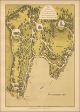
The 1768 Map of Canton Uri and Valle Leventina: A Geographic and Historical Examination
This remarkable map offers an intricate portrayal of Canton Uri and its surrounding regions. Crafted by Gabriel Walser, it provides a geographic and historical window into this central part of Switzerland.
The topography of the map reveals the pronounced Alpine mountains, indicative of the region’s rugged terrain. These peaks, particularly the Uri Alps, play a crucial role in defining the landscape and climate of the area. The depicted rivers, including the Reuss River, are essential not just as water sources but also as key transportation and trade routes. The bridges spanning these rivers, some of the most notable being the Devil’s Bridge, signify vital connectivity points in this rugged terrain. The high Alpine lakes, especially Lake Lucerne (shown here at its southern tip), underscore the region's natural beauty and its importance as a hub for trade, transport, and fishing.
A significant addition to the map is the inset detailing Valle Leventina. This valley, located to the south of Uri, is strategically positioned leading to the Saint Gotthard Pass, one of the primary mountain passes in the Alps. Valle Leventina has its network of towns, roads, and rivers, most notably the Ticino River. The visual portrayal of the waterfall in the Schachen valley – "des schonen wasserfalls im schachen thal des Cantons uri" – provides a geographic marker, emphasizing the region’s rich hydrological features.
Altdorf stands out prominently on the map. As the capital of Uri, it has been historically significant for centuries. Its proximity to Lake Lucerne and the Reuss River made it an important trade and administrative center. Flüelen, situated on the southern tip of Lake Lucerne, is the other notable town. Its position made it a vital port and a nexus for goods and people moving in and out of the Canton.
The history of Canton Uri is intrinsically tied to the early formation of Switzerland. Uri, alongside Schwyz and Unterwalden, were the initial members of the Swiss confederation in 1291. This Eternal Alliance was a defensive pact against external threats and internal strife. Uri's geographical position made it crucial in controlling the Gotthard Pass, a critical route for trade between northern and southern Europe. By the time this map was crafted in 1768, Uri had witnessed several pivotal events. The 15th and 16th centuries saw Uri expanding its territories, including parts of Valle Leventina.
Homann Heirs was a German publishing firm that enjoyed a major place in the European map market throughout the eighteenth century. Founded in 1702 by Johann Baptist Homann, the business passed to his son, Christoph, upon Johann’s death in 1724. Christoph died in 1730, aged only 27, and the firm was inherited by subsequent Homann heirs. This altered the name of the company, which was known as Homann Erben, or Homann heirs. The firm continued in business until 1848.
Gabriel Walser he began his theology studies in Basel in 1712, and, after study visits in Marburg, Tübingen, Jena, and Halle, he completed his examination there in 1717. He became a member of the Appenzell Synod. In 1718, he married Maria Elisabeth Zollikofer, who hailed from a noble St. Gallen family and was the daughter of Ruprecht Zollikofer. In 1721, he was elected as the pastor of Speicher, where he served from 1721 to 1745. In the land trade, he took the side of the defeated Lindens and was thus fined in 1732. In 1745, he took up the pastoral position in Berneck, which he held until his death.
In addition to his duties as a pastor, Gabriel Walser wrote the "Old and New Appenzeller Writing Calendar" for the years 1738 to 1745, a collection with easy-to-understand scientific, historical, and narrative content.
His main work was the "Neue Appenzeller-Chronick or Description of the Canton of Appenzell of the Inner and Outer Rooden", self-published in 1740. This history of the Canton since Roman times also included geographic descriptions, including a map of Appenzell. It contained an appendix with various documents from the years 1378 to 1667 and an official directory. Walser's chronicle is considered an extension and continuation of the Appenzell Chronicle of the pastor Bartholomäus Bischofberger from Trogen, which goes up to the year 1682. The more valuable, regional part of the chronicle is based on his observations. The historical part connects to Bartholomäus Bischofberger's work and supplements it up to 1732. His continuation for the years 1732 to 1772 was only published in 1829.
For the Augsburg publisher Matthaeus Seutter, Walser created maps of the cantons Lucerne, Uri, Schwyz, Glarus, and Appenzell as well as Graubünden, after numerous trips through eastern and central Switzerland. For the "Atlas Novus Reipublicae Helveticae", published in Nuremberg in 1769, he created,15 maps covering 18 cantons covering the 18 cantons of the Old Confederacy (excluding Schaffhausen) and the territories of St. Gallen, Graubünden, and Wallis, based on maps by Johann Jakob Scheuchzer, Hans Konrad Gyger, and others,from 1763 to 1768. Walser did not carry out any surveys for this. However, his maps represent a slight qualitative improvement compared to Scheuchzer's maps. In 1770, Walser's "Swiss Geography with the Sights in the Alps and High Mountains" was published in Zurich. This is an explanation of the atlas.
![[Baden]. Designatio civitatis Badensis Helveticae, una cum oppidulo thermarum](https://storage.googleapis.com/raremaps/img/small/83126.jpg)
![[Canton Berne and Terre de Saint Claude]](https://storage.googleapis.com/raremaps/img/small/29668.jpg)

![[6 Sheet Map] Theatre de la Guerre en Savoye et en Piemont -- Le Dauphine, La Bresse Partie du Lionnois et de La Provence](https://storage.googleapis.com/raremaps/img/small/62561.jpg)