|
||

|

|
|

|
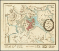
Stock# 97040
Description
Decorative pictorial map of Boston, with 3 large inset views of various parts of the City.
The map shows streets, parks, city blocks, Rapid Transit Lines, surface and underground trolley lines and bus routes, city landmarks, including hotels, Fenway Park, Tufts Medical and Dental School, government buildings, etc.
Colorful border at upper and lower edge is a series of vignette bird's eye view of Boston: top left features several of the buildings of the Harvard campus, at lower right is Pleasure Bay, Commonwealth and Fish Pier.