|
||

|

|
|

|
Rare San Diego Subdivision Map: a Proto-Streetcar Suburb
Early Female Real Estate Investor
Extinct South Park Street Names : When Fern Street was Despard St. and Ivy St. was Horton Ave.
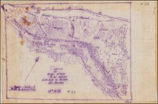
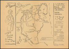
A wonderful pen and ink San Diego subdivision map which shows Watkins and Biddle's Addition, part of the present-day South Park neighborhood. The area shown is south of the San Diego neighborhood of Burlingame, just east of Balboa Park. Made during the boom that ensued in the surrounding areas of Horton's Addition during the 1880s, the map is notable for using now defunct street names for an area that is now the heart of a historical community of craftsman bungalows. The map dates from the boom or speculative era from 1885-1887. At that time, San Diego was in a phase of rapid development and transformation. The late 1880s marked a pivotal moment in the city's history, with the arrival of the Santa Fe Railroad connecting it to the rest of the nation and subsequently fueling its steady expansion.
The Watkins and Biddle's Addition subdivision was a small but unique (among early San Diego subdivisions) tract located west of 32nd. Street and north of Grape, in the present-day South Park neighborhood. Notably, one of the investors in the subdivision was Ella Biddle, who was the namesake of one of the streets on the map (since renamed Juniper). In fact another street in the vicinity was named Ella (not shown on the map). None of the street names on the present map survived. The unusual horizontal layout of the blocks which characterizes the tract helps us pinpoint the area shown as bounded by Fern Street on the west (here Despard St.); 32nd Street on the east (here Babcock St.); Juniper Street on the north (here Biddle Ave.); and Grape Street on the south (here North Ave). The north-south street through the center of the map is present-day 31st Street. City Park (Balboa Park) is noted as being to the west of the area shown on the map. The scale is 100 feet to 1 inch. Blocks are 300 x 600 feet; lots 25 x 140 feet; avenues 80 feet wide; streets 60 feet wide; alleys 20 feet wide.
The fairly extensive red ink and pencil annotations suggest the map was used in the sale of lots. Owners' names are scribbled on a few lots (including one lot retained by Ella Biddle, located on Horton Ave., now Ivy Street). Given the defunct street names on the map, as well as the general material quality of the map itself, we attribute a date of production to circa 1886, the year Watkins and Biddle's Addition was filed with the County Recorder. By the first decade of the 20th-century the modern-day street names were well established for these streets.
Interestingly, the misalignment of Fern Street at Grape Street is indicated with a pencil sketch in the lower left corner (here Despard Street at North Ave.). This correction further confirms the corresponding present-day street names, whose layout otherwise generally conforms to our map. Besides the interesting horizontal alignment of the blocks in Watkins and Biddle's Addition, the subdivision stands out as one of the first imagined street car suburbs in San Diego.
The San Diego Street Car Company and the San Diego Electric Railway Company
The extinct street names herein offer a clue to the timeframe and owners of the subdivision. Horton Ave is an obvious nod to New San Diego's founder and most prominent early promoter, Alonso E. Horton. Story Street is likely named for H. L. Story, while Babcock Street is almost certainly named for E. S. Babcock, the builder of the Hotel del Coronado. Tellingly, Story and Babcock were also the founders of the San Diego Street Car Company, which started a horse-drawn streetcar service on July 3, 1886. The first electric-powered streetcar service in San Diego debuted later that year. It would not be a stretch to suggest that Story and Babcock were likely planning a streetcar connection with this part of South Park even at this early date (1886). It would take a few more years and the financial muscle of a Sugar Baron before the area became an actual street car suburb.
By the early 1890s John D. Spreckels, owner of the San Diego Electric Railway Company, used some of his sugar industry wealth to begin consolidating San Diego's streetcar system. He eventually bought out many of the smaller streetcar lines, including Story and Babcock's San Diego Street Car Company, as well as the later South Park and East Side Railway, which actually connected South Park to Central San Diego sometime in first few years of the 20th century.
South Park
The Watkins and Biddle's Addition is now the center of South Park, a charming San Diego neighborhood filled with classic craftsman bungalows. Construction of homes in the area took off in the first decade of the 20th-century. Ella Biddle, the early investor mentioned above, was reportedly building a home on her Ivy Street lot in 1906:
Mrs. Biddle, one of the original owners of the Watkins and Biddle tract (located west of 32nd and north of Grape), waited until the streetcar arrived before building a residence. The San Diego Union reported “now that the car line is so close, she expects to build at once and enjoy the perfect view and salubrious climate of this delightful addition.” - San Diego Union, June 20, 1906, page 10.
The entire area encompassing both the Watkins and Biddle tract and the surrounding South Park Addition tract is now considered a historical district. According to a proposal by the Save Our Heritage Organization:
The South Park Addition was central to a neighborhood already known as Brooklyn Heights... The initial deed restrictions within the development may have imposed economic barriers for some income groups... Within South Park, Fern Street became another thriving thoroughfare, with grocery stores and other shops appearing at the transit stops [this would be the area along Despard St. on the present map]... The neighborhood of South Park is significant as a historic district under Historical Resources Board Criterion A as a special element of San Diego's historical and architectural development, reflecting streetcar suburban development in San Diego and Golden Hill, as well as a variety of pre-1950 architectural styles, including Craftsman, Prairie, Colonial Revival, Mission Revival, Tudor Revival, Spanish Eclectic, Streamline Moderne and Minimal Traditional/Tract Ranch some of which can be attributed to Master Architects and Builders... Though property sales abounded between the years 1885 and 1887, the majority of real estate activity was speculative and involved the sale of vacant parcels...
Streets, names, and other sites or annotations on the map:
- North-South streets: Despard, Story, and Babcock (likely present-day Fern, 31st, and 32nd Streets, respectively)
- East-West streets: Biddle Ave, Horton Ave, Watkins Ave, and North Ave. (likely present-day Juniper, Ivy, Hawthorn, and Grape Streets)
- Names: C. A. Goodman; J. C. DeWitt, Thos. D. Newton, Flemming Hall, E. Biddle, F. Howell, Shuttleworth, Lewis, and others.
- Methodist Episcopal Church on a pair of adjoining lots at present-day north-east corner of Fern and Hawthorn Streets.
Rarity
Original 19th-century San Diego subdivision maps are very rare. This is the only original subdivision map of the Watkins and Biddle tract we have ever seen in the market.