|
||

|

|
|

|
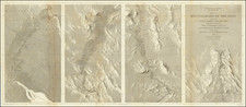
Twenty Lake Basin Back of Saddlebag by Hal offers an interesting portrayal of the Saddlebag Lake area, nestled in the eastern Sierra Nevada Mountains of California. The map's detailing, from hiking trails to the area's altitudinal lakes, provides an invaluable tool for understanding the landscape and its myriad attractions. This region, lying close to the eastern entrance of Yosemite National Park, holds significant geographical and recreational importance.
In the late 19th and early 20th centuries, as the American West was extensively explored and mapped, regions such as the Sierra Nevada became celebrated for their breathtaking landscapes and untouched wilderness. Yosemite National Park, formally designated in 1890, was a testament to the nation's evolving appreciation for the preservation of natural wonders. The Saddlebag Lake area, lying in proximity to the park's eastern entrance, epitomizes this untouched beauty. The mentioned "Yosemite Boundary" on the map firmly establishes its proximity to this renowned national treasure.
This map also accentuates the recreational amenities in the region. It not only delineates the natural topography but also marks areas of human activity and interest, from public campgrounds to the Saddlebag Lake Resort. The inclusion of amenities such as "Water Taxi Service" and "Fishing Information Deck" suggests the map's utility to visitors and adventurers keen on exploring the "Twenty Lake Basin" and other surrounding attractions.
Topographical landmarks, such as the Tioga Peak with an elevation of 11,532 feet, and the Conness Glacier, emphasize the ruggedness and altitude of the terrain. Notably, the map highlights a myriad of lakes — from Gardisky to Fantail — reinforcing the area's popularity among anglers and hikers. Their names evoke the region's natural heritage and the intricate tapestry of ecosystems present in the Sierra Nevada.
In conclusion, Twenty Lake Basin Back of Saddlebag serves as both a guide and a historical record. Through its delineations, it encapsulates the allure of the Sierra Nevada's eastern terrains, capturing both the grandeur of nature and the evolving interplay of human activities within it.
Date very roughly estimate.
![[ Southern California Tourism ] Hunting and Fishing in Southern California on the Santa Fe](https://storage.googleapis.com/raremaps/img/small/101613.jpg)