|
||

|

|
|

|
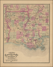
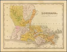
Rare 1846 edition of T.G. Bradford's large map of Louisiana.
The map is hand colored by Parishes, and shows towns, forts, lakes, rivers, and some of the very earliest railroad lines in the South.
Many of the early western and northern parishes have not yet been formed, and the area is dominated by massive Opelousas, Rapides, Natchitoches, Claiborne and Ouachita Parishes.
Thomas Gamaliel Bradford (1802-1887) was an American geographic publisher. He hailed from Bradford, Massachusetts and began his publishing career by working for the America Encyclopedia. Then, he edited and republished the Atlas Designed to Illustrate the Abridgement of Universal Geography, Modern & Ancient, which had originally been offered in French by Adrian Balbi. In 1835, he published another atlas, A Comprehensive Atlas: Geographical, Historical & Commercial, and, in 1838, An Illustrated Atlas Geographical, Statistical and Historical of the United States and Adjacent Countries. His interests were primarily in educational publishing and he was one of the first mapmakers to show Texas as an independent country.