|
||

|

|
|

|
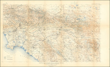
Fascinating vintage geological map of the Los Angeles Basin and the mountains to the north, extending through Santa Barbara County into the Sierra Madre.
The map was compiled by Charles Jennings and Rudolph Strand in 1969, with this edition being printed in 1971. The format follows the earlier maps by the important California geologist Olaf P. Jenkins. The map wsa published by the Resources Agency of the Department of Conservation.
A key to strata ranging in age from Precambrian to Quaternary (modern) is shown to the right of the map. This names the numerous types of rocks found in the area, and provides detailed information regarding geological units, including facies analysis (where sedimentary rocks were deposited) and information about the crystallinity of igneous rocks.
The many faults found in Los Angeles feature prominently on the map. The famous Santa Monica and Newport-Inglewood Fault zones can all be located. The Newport-Inglewood Fault is part of the fault system which acts as a boundary between the North American Plate and the Pacific Plate. Risk analysis has shown that a large rupture on the fault (Mw 7.3-7.4) could cause the first trillion-dollar natural disaster. The even more famous San Andreas fault appears in the upper right, near Lancaster.
![[Hollywood / Los Angeles] Castle's Inc. Hollywood's Complete Camera Store](https://storage.googleapis.com/raremaps/img/small/73017.jpg)