|
||

|

|
|

|
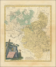
Spain and Portugal, published by William Lizars in Edinburgh around 1830, captures the detailed topography and political geography of the Iberian Peninsula during a particularly tumultuous time in its history. The map encapsulates both Spain and Portugal, delineating their regional boundaries, significant cities, and key geographical features, all the while showcasing Lizars' characteristic finesse in cartographic representation.
The 1830s were a decade of profound change for the Iberian Peninsula. In Spain, the death of Ferdinand VII in 1833 initiated the Carlist Wars, a series of civil conflicts fought between the supporters of the Infante Carlos and those of Ferdinand's daughter, Isabella II, over the Spanish throne. Portugal, on the other hand, was emerging from its own civil conflict, the Liberal Wars, which concluded in 1834 with the establishment of a constitutional monarchy. This map, therefore, not only provides a geographical representation of the peninsula but also serves as a historical record of the territories and boundaries contested during these upheavals.
William Lizars, a Scottish engraver, was renowned for his clarity and precision in cartographic representation. His works often melded beauty with functionality, ensuring that the maps were not only visually pleasing but also informative. The detailing of Spain and Portugal reveals a careful study of both topographical and political nuances, an aspect that speaks volumes of the expertise and dedication Lizars poured into his craft.
The detailed depiction of cities, towns, and geographical landmarks offers a glimpse into the urban and natural landscapes of Spain and Portugal in the 1830s. It is a testament to the complexity of the region’s topography, from the rugged Pyrenees to the flowing Guadalquivir River, painting a vivid picture of the Iberian Peninsula's diverse landscapes.
In essence, this map serves as an intersection of art, geography, and history. It reflects the significant socio-political changes occurring within Spain and Portugal and stands as a testament to the unparalleled cartographic skills of William Lizars during the 19th century.
The Lizars were a Scottish family of engravers and printers who produced many views and maps. Daniel Lizars Sr. (1754-1812) was the son of a shoemaker, but he apprenticed with Andrew Bell, a printer and engraver. Lizars set up his own printworks near St. Giles Cathedral and took on his own apprentices, including George Bartholomew, whose son John would go on to found the important mapmaking firm later know as John Bartholomew & Son Ltd.
Daniel Sr. had three sons: Daniel Jr., John, and William Home. He also had a daughter, Jane Home. Daniel Jr. (1793-1875), the youngest of the boys, apprenticed in his father’s shop alongside George Bartholomew. When his father died in 1812, Daniel Jr. took over much of the business, expanding it and specializing in maps. The company went bankrupt in 1832, however, and Daniel emigrated to Canada.
John Lizars (1792-1860), the middle son, studied medicine and became Professor of Surgery at the Royal College of Surgeons of Edinburgh, as well as senior surgeon at the Royal Infirmary of Edinburgh.
William Home Lizars (1788-1859), the eldest, also apprenticed in his father’s shop. After learning engraving, William entered the Trustees’ Academy to learn under John Graham. He was a skilled painter and artist. When his father died, and after his Daniel Jr. left, he carried on printing and invented a method of etching that looks like wood engraving.
![[ Azores ] Insulae Tercerae alias Açores](https://storage.googleapis.com/raremaps/img/small/101449.jpg)
![[Bay of Biscay] Paskaerte Vande Bocht van Vranckrijck Biscajen en Galissen tuscchen Heylant en C. de Finisterre](https://storage.googleapis.com/raremaps/img/small/83967.jpg)