|
||

|

|
|

|
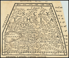
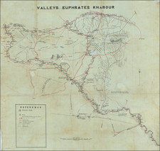
Parthian Empire during the reign of Mithridates I (circa 171–132 BC) and Key Transit Corridor on the Silk Road
Fascinating map of the Parthian Empire during the reign of Mithridates I, offering a remarkable look back at one of the most powerful empires of the period, strategically located on the Silk Road.
The Parthian Empire, existing from the late 3rd century BC until the 3rd century AD, was a formidable power that came to dominate much of present-day Iran and extended into parts of neighboring territories. The present map provides a glimpse into this empire, marking its vast territories and important landmarks.
Geographically, the map would have emphasizes the vast expanses the Parthians controlled. Major rivers, such as the Euphrates and Tigris, mark the western boundaries, while mountain ranges like the Zagros serve as critical geographical landmarks. Key cities like Ctesiphon, the empire's capital, are highlighted, signifying their importance in the political and economic landscape of the empire. Beyond the capital of Ctesiphon, Nisa near present-day Ashgabat was an early Parthian capital with a significant royal fortress. Hecatompylos, another early capital, was strategically placed at the intersection of major trade routes. Ecbatana, today's Hamadan in Iran, was known for its grand palace and served as a summer residence for Parthian rulers. Seleucia, by the Tigris River, was a bustling trade and cultural hub, rivaling the size and importance of ancient Rome and Alexandria. Dura-Europos in present-day Syria stood as a fortified city on the frontier of the Parthian and Roman empires, reflecting a mix of cultures. Merv, an oasis city on the Silk Road, thrived due to its strategic position, while Rhagae, near modern Tehran, emerged as a cultural epicenter. Finally, Charax Spasinu near the Persian Gulf underscored the empire's maritime trade significance. Together, these cities painted a vivid picture of a diverse and economically vibrant empire.
One particularly notable feature on the map is the reference at Herat, stating, "Here in Alexander's time stood the Royal Palace of the Prince's of Aria." This annotation offers a vivid connection to the region's history, notably the presence of Alexander the Great.
By 141 BC, the Parthian Empire was in a phase of considerable expansion. Mithridates I, who reigned from around 171-132 BC, was the architect of much of this expansion. By the time of this map, territories in modern-day Afghanistan and parts of Central Asia had been incorporated into the empire. The Parthian control and influence stretched far and wide, making them a significant player in regional geopolitics.
Relations with neighboring powers, especially the Seleucid Empire from which the Parthians took over many territories, would have been of paramount importance. The Seleucid Empire was in decline, and the Parthians were keen on filling the power vacuum it left, leading to several conflicts and territorial skirmishes.
Parthian Empire and the Silk Road
The Parthian Empire's strategic position made it a pivotal player in the complex trade network known as the Silk Road, a series of interconnected routes that facilitated the exchange of goods, ideas, and cultures between the East and West.
The Silk Road wasn't just a single path but rather a vast web of terrestrial and maritime routes connecting China, Central Asia, India, the Middle East, and the Mediterranean world. With its territories spanning modern-day Iran and parts of Central Asia and the Middle East, the Parthian Empire effectively controlled the central corridor of the Silk Road, acting as a bridge between the Han Dynasty in China and the realms of the Mediterranean.
This central position allowed the Parthians to reap significant economic benefits. They acted as middlemen, facilitating and taxing the trade of goods like silk from China, spices from India, and luxury goods from the Roman Empire. The Parthians themselves exported items like horses – highly prized in China – and other local goods to distant markets.
However, the Silk Road wasn't just about commodities. It was a conduit for cultural, technological, and intellectual exchange. Through the Parthian Empire, innovations like Chinese papermaking techniques, Indian astronomy and mathematics, and Greco-Roman art and philosophy spread, enriching societies along the route.
This role also had strategic implications. The wealth derived from trade bolstered the Parthian economy, allowing it to maintain strong armies and fortifications. Furthermore, the knowledge and technology exchange – including advancements in military technology – would have benefitted Parthian defense and administration.
The Parthian cities, such as Ctesiphon, Nisa, and Merv, became bustling centers of trade and culture, where merchants from diverse backgrounds met, exchanged goods, and shared stories from their homelands. The cosmopolitan nature of these cities is a testament to the empire's crucial role in Silk Road trade.
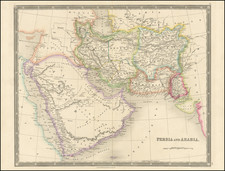
John Thomson (1777-ca. 1840) was a commercial map publisher active in Edinburgh. He specialized in guide books and atlases and is primarily known for his Atlas of Scotland (1832) and the New General Atlas, first published in 1817 and reissued for the next quarter century. The New General Atlas was a commercial success—it was also published in Dublin and London—and it compiled existing geographic knowledge in compelling ways for a wide audience.
His Atlas of Scotland introduced new geographic information and was the first large-scale atlas of Scotland to be organized by county. It provided the most-accurate view of Scotland available before the Clearances. Work on the atlas began in 1820 and led to Thomson’s bankruptcy in 1830 due to the high costs of gathering the latest surveys and reviewing the required materials. Despite the publication of the atlas, Thomson declared bankruptcy again in 1835.