|
||

|

|
|

|
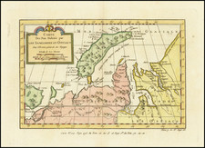
Fascinating map focused on the Hudson Strait and environs, published in the middle of the 1820s.
The Hudson Strait, a historically significant and geographically intricate passage, forms the primary waterway to Hudson Bay, a colossal body of water lying in the heart of Canada.
The drive to discover a Northwest Passage, a direct maritime route from Europe to Asia via North America's Arctic coastline, fuelled much of the exploration in the Hudson Strait and its environs. The potential economic benefits of finding such a route, coupled with the allure of uncharted territories, provided the impetus for many expeditions from the 16th century onward.
The present map provides both an up to date understanding of the region and a compilation of the discoveries of some of the earliest European exploratory missions.
-
Luke Fox's Discoveries (1631): The map highlights the lands discovered by the English explorer Luke Fox. His journey was part of the larger English quest for the Northwest Passage. While he failed in finding the passage, his meticulous recordings expanded European knowledge of the Arctic regions.
-
Esquimaux Lands: By showing the Esquimaux (now called Inuit) lands, the map acknowledges the indigenous inhabitants of the region. Their profound understanding of the terrains and waters played an unsung but crucial role in assisting European explorers.
-
Strait Discoveries: Both the Davis Strait, revealed by John Davis in 1585, and the Frobisher Strait, named after Sir Martin Frobisher's journey in 1576, are displayed. Contrary to earlier beliefs, these are not straits but rather expansive bays of Baffin Island.
-
Digges Islands: The western section of the map brings attention to the Digges Islands, encountered by Henry Hudson in 1616. These islands commemorate Sir Dudley Digges, a friend of the famed explorer Henry Hudson. Although not an explorer himself, Digges' financial ventures in the Virginia Company of London and his support for Hudson’s voyages etched his name on the map, quite literally.
While the aforementioned discoveries predate the 19th century, they laid the groundwork for the heightened exploration in the first half of the 19th Century The promise of the Northwest Passage reignited interest in the region.
During this time, multiple expeditions were launched. Sir John Ross and William Parry, both naval officers, made significant contributions in the early 19th century. Their voyages illuminated much of the Arctic's geography and were foundational for subsequent missions.
Philippe Marie Vandermaelen (1795-1869) was a Belgian cartographer and geographer known for his pioneering use of technology and his leadership in establishing the important Establissement geographique de Bruxelles. Born in Brussels, Philippe was obsessed with maps from a young age. He taught himself mathematics, astronomy, and mapmaking and plotted the battles of the Napoleonic wars avidly. He took over his father’s soapmaking business briefly in 1816, but then turned it over to his brother in favor of cartography.
From 1825 to 1827, he released his first atlas, the Atlas universal, which was well received. It was sold in forty installments of ten maps each, with 810 subscribers listed. The atlas contained 387 maps in six volumes at a uniform scale of 1:1.6 million. The maps were intended to be joined and together would create a globe 7.755 meters wide. It was the first atlas to show the entire world on a large uniform scale and was the first atlas produced using lithography. This project served as Vandermaelen’s gateway into intellectual life, gaining him membership in the Royal Academy of Sciences and Belles-Lettres of Brussels (1829).
In 1830, Vandermaelen inherited a laundry from his parents which he converted into the Establissement geographique de Bruxelles, or the Brussels Geographical Establishment. His brother, Jean-Francois, also established a botanical garden on the site. The Establishment had its own lithographic press, one of the first to use the technology for cartography and the first in Belgium. They produced textbooks, surveys, and especially maps of Brussels to be used for urban planning. The complex also housed schools, an ethnographic museum, and a library open to the public. Vandermaelen was passionate about geographic education and saw the Establishment as an open place where people could learn about the world.
In 1836, he was knighted for his services to geography and the intellectual community of Belgium. He died at age 73 in Molenbeek-Saint-Jean, near the Geographical Establishment that he founded. After Vandermaelen’s death, the Geographical Establishment declined, closing its doors in 1880. The extraordinary collection they had amassed passed to several institutions, most importantly the Royal Library of Belgium.
![[Inhabitants of New France] Einwohner von neu Frankreich](https://storage.googleapis.com/raremaps/img/small/94772.jpg)