|
||

|

|
|

|
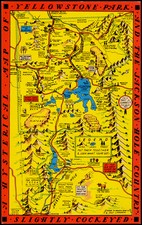
A Sketch Map of Western Montana by the Chamber of Commerce of Missoula, dated to the mid-20th century with art by J.S. Swan, provides a vivid representation of Western Montana, detailing major highways, trails, and points of historical interest. This folding pictorial map, printed on both sides, further offers a glimpse into the vibrant locale of Missoula, often referred to as "Where The Trails Meet". With the verso offering essays on Missoula and four strip maps of major highway connections, the map and its annotations delve deep into Montana's unique geographical and historical character.
In the era this map was produced, Missoula emerged as a pivotal crossroad in Western Montana, strategically situated where various trails converge, hence its moniker. The map underscores the network of highways, such as U.S. 10S to Butte, U.S. 10N to Helena, and U.S. Highway No. 93 to Glacier, which facilitated access to multiple valleys radiating out from Missoula. This system of roads, both primary and secondary, illustrates the region's vibrant interconnectivity and its growing importance as a hub of commerce, travel, and exploration.
The annotations of the map further provide intriguing insights into the area's rich history and natural beauty. They detail the relics of Montana's gold rush days, with tales of old mining towns like Garnet and the extraction of gold from these sites. The region's breathtaking landscapes, from Rock Creek's allure for anglers to the majestic grandeur of the Flathead Valley, emerge vividly in the descriptions. Travelers of that time would have been enchanted by the "heights of grandeur" and "dream spots of beauty" that greeted them at every mile.
Beyond its natural allure, the map's annotations emphasize cultural interactions and historic landmarks. The Flathead Indian reservation and its picturesque tribesmen are highlighted, giving a nod to the region's Indigenous history and its continued significance in the modern landscape. The descriptions also draw attention to areas of commercial and academic significance, such as the Montana State University and the bustling industries around Missoula, from lumbering to sugar production.
In conclusion, A Sketch Map of Western Montana by the Chamber of Commerce of Missoula stands not merely as a cartographic tool but as an encapsulation of Western Montana's socio-economic, cultural, and natural heritage. Its intricate engravings, coupled with detailed annotations, provide a window into a Montana that was on the cusp of modern transformation, simultaneously cherishing its history and embracing its future.