


|
||

|

|
|

|
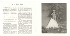
Sketch Showing a Strip of Land... in the San Dieguito Cañon, drafted by Thos H. James C.E. on March 9th, 1907, represents a proposed water main project across the property of A. Barnett near Del Mar, San Diego, California. This blueline cyanotype delineates a ten-foot-wide strip of land, capturing an infrastructure endeavor in the burgeoning Del Mar region. The map references the notable San Dieguito Rancho and marks the property holdings of the Santa Fe RR Company, illustrating the intersections of land use, development, and infrastructure.
The turn of the 20th century was a period of growth and infrastructural advancements in California. With the expansion of the railroad system and the onset of urbanization, there was an increasing need for structured water supply networks. San Diego, being a region of arid landscapes and burgeoning communities, presented a unique challenge. Infrastructure projects like the one documented in this map were instrumental in transforming the barren terrains of California into thriving settlements.
Thos H. James' cyanotype map offers a glimpse into this transformative era of Californian history. Blueline cyanotyping, a popular method of reproducing documents at the time, lends the piece a characteristic blue tint. The precision and detail in the cartography reflect the significant considerations involved in urban planning and the challenges of integrating natural landscapes with human requirements.
Today, the area illustrated on the map has evolved into significant landmarks—the Del Mar Race Track and the 5 Freeway, bordered by the serene San Dieguito Lagoon State Marine Conservation Area. These contemporary landmarks underscore the dynamic evolution of the region and the importance of archival cartographic pieces in tracing the lineage of urban growth and development.
![Southeastern Portion of California [San Diego, San Bernardino and Inyo Counties]](https://storage.googleapis.com/raremaps/img/small/83750.jpg)
![[Mission San Luis Rey] Vue de La Mission de Saint Louis Roi De France](https://storage.googleapis.com/raremaps/img/small/71720.jpg)