


|
||

|

|
|

|
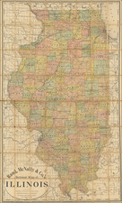
Scenic and Historic Illinois State of Illinois, commissioned under the governorship of William G. Stratton in 1953, offers a comprehensive representation of the state's significant historical and recreational sites. The map depicts markers such as the locations of the Lincoln-Douglas debate, the Lincoln National Memorial Highway, and an array of state parks, memorials, and wildlife conservation areas. A poignant detail to note is the emphasis on the exact locations of these landmarks, with the reverse side providing a descriptive text and a highway map for precision. This item offers a unique insight into the mid-20th-century perception of Illinois's historical and natural heritage.
The 1950s marked a period of increased nationalistic pride and remembrance in the United States. This was a time of post-World War II prosperity and the commencement of the Cold War. Within this context, states sought to establish a cohesive identity, reinforcing their historical and cultural significance. In Illinois, this was epitomized by the emphasis on historical events like the Lincoln-Douglas debate, a series of political confrontations that had long-lasting implications for the country's political landscape.
The technique of the map, lithographed by Rand McNally & Co., speaks to the robust cartographic traditions of the time. The map is not just a geographical representation but an interweaving of history and geography, placing landmarks in context while also acknowledging spatial constraints, as seen with the illustrative placement of the Starved Rock State Park. Such considerations highlight the balance between the artistic representation and geographical accuracy pursued by cartographers in this era.
This map serves as a testament to Illinois's commitment to both its natural beauty and its storied past. Whether it's the preservation of wildlife through fish rearing units and game refuges or the honoring of political legacies with designated memorials and highways, the state's essence is eloquently captured in this piece. The document stands as a testament to a period where historical consciousness and recreational appreciation converged, all against the backdrop of a vibrant mid-century America.
Rand McNally & Co. is a large American map and navigation company best known for its annual atlases. The company got its start in 1856, when William Rand opened a print shop in Chicago. He was joined in 1858 by a new employee, Andrew McNally. Together, the men established their namesake company in 1868. Originally, the company was intended to print the tickets and timetables for the trains running to and through Chicago; their first railway guide was published in 1869.
By 1870, they had shifted from just printing to publishing directories, travel guides, and newspapers. Their first map appeared in 1872 in a railway guide. The map was produced using a new wax engraving method, a cheaper process that gave the company an edge.
By 1880 Rand McNally had entered the education market with globes, wall maps, and geography texts for students. In 1923, Rand McNally published the first Goode’s World Atlas, named after its editor, Dr. J. Paul Goode. For generations afterward, this would be the standard classroom atlas.
In 1899, William Rand left the company, but McNally and his family remained, controlling the company for over a century. In 1904, they published their first road map intended for automobiles and by 1907 were publishing Photo-Auto Guides, which combined photography and mapping to help drivers. In 1924, they produced the Auto Chum, a precursor to their famous road atlases. Rand McNally would remain the leader in road maps and atlases throughout the twentieth century.
In 1937, Rand McNally opened its first store in New York City. Ever on the frontier of technology, Rand McNally pioneered the scribing process for printing tickets in 1958 and printed their first full-color road atlas in 1960. Arthur Robinson developed his now-famous projection of Rand McNally in 1969. By the 1980s, the company was exploring digital reproduction and digital databases of maps for truckers. In the 1990s, they lead the charge to develop trip-planning software and websites. Today, most of its products are available online or in a digital format, including maps for tablets and phones.

![[ World ] Air France -- Sur Les Ailes D'Air France Decouvrez Le Monde A Votre Tour](https://storage.googleapis.com/raremaps/img/small/100053.jpg)