


|
||

|

|
|

|
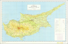
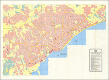
Survey of Cyprus Motor Map Seventh Edition, printed by the Ordnance Survey in 1958 and initially compiled and drawn under the direction of F. J. Salmon in 1932, is an intricate portrayal of the transportation and geographic features of Cyprus during the mid-20th century. It delineates the island’s asphalted roads, secondary pathways, and other significant routes, while also offering a meticulous account of varied features ranging from town insets with principal motor routes, railway lines, post offices, and heights of principal mountains, to ancient sites and principal antiquities.
The post-war years of the 1950s were pivotal for Cyprus. With the shadow of the Second World War still fresh, the island found itself amid political upheavals and increasing calls for independence from British colonial rule. It was against this backdrop that the Survey of Cyprus Motor Map emerged, capturing not only the physical layout of the island but also providing a geographical reflection of its intricate historical and socio-political landscape. The map's careful differentiation between asphalted roads and secondary roads, for instance, can be seen as an indirect commentary on the island's developing infrastructure and urbanization trends.
Incorporating both modern and ancient features, the map stands as a testament to the rich tapestry of Cypriot history. It meticulously details ancient sites, including locations like Salamis, juxtaposing these with contemporary features such as railway lines, post offices, and police stations. Such a juxtaposition underscores Cyprus's unique position as a crossroads of civilizations, where the ancient and the modern have coexisted for millennia.
The insets dedicated to towns such as Nicosia, Kyrenia, and Limassol serve to further elaborate on the island's urban centers, granting a detailed view into the spatial configurations of these urban hubs. Furthermore, the clear warning about the changing road conditions and gradient specifications highlights the practical nature of this map, designed for both the traveler and the local in an age before digital navigation. Such detailed features exemplify the map's role as both an artistic representation and a utilitarian tool for understanding Cyprus in the 1950s.
![[The Travels of Paul] Tabula Geographica, in qua omnes regiones, urbes, oppida, et loca describuntur, quorum mentio fit in Actis et Epistolis Apostolotum, et Apocalypsi; de integro multis in locis emendata, ac regionum limitibus distincta, auct. Pet. Planc. . . .](https://storage.googleapis.com/raremaps/img/small/77970.jpg)