|
||

|

|
|

|
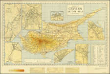
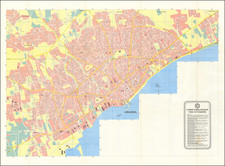
Survey of Cyprus Administration Map, compiled and drawn under the guidance of F. J. Salmon, serves as a detailed chronicle of the geographical nuances of Cyprus as of the late 1950s. Printed by the Ordnance Survey in Southampton, this map offers an intricate understanding of the Mediterranean island's terrain, spanning its ancient sites, district boundaries, and transportation systems.
The precision of this map, resulting from large-scale revenue surveys, is underlined by its attention to topographical details, such as the heights of principal mountains and hills, denoted in feet. Notably, the map also marks approximate heights of localities, principal passes, and specific features like streams that run dry except during rainfall. This level of detail underscores the topographical and geographical intricacies of Cyprus.
The transportation routes, including asphalted roads, other maintained roads, and the railway line, are clearly outlined, offering insights into the infrastructural developments of the era. Moreover, the presence of a telephone network outside the towns speaks to the early stages of technological integration within the island's communities. The conventional reference grids, arranged systematically, provide a structured layout, making the map both a functional tool and a testament to the intricate art of cartography during this period.