|
||

|

|
|

|
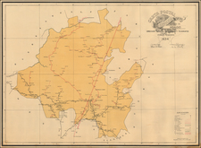
Amer. Sep. No. 64 Partie Du Mexique, produced by Philippe Marie Vandermaelen in 1825, stands as an exceptionally detailed cartographic representation of a segment of Mexico, extending from Mazatlan and Zacatecas in the North to Valladolid and Tetela Rio in the South, encompassing regions like Guanajuato and the entirety of Guadalajara. The map delineates geographical features such as mountains, lakes, towns, roads, and rivers, making it one of the most intricate regional maps from its time.
The 1820s was a pivotal era for Mexico. Following its independence from Spain in 1821, the country experienced significant political and territorial changes. The map, therefore, serves as a window into this newly sovereign nation's evolving landscape and socio-political environment. Regions like Guanajuato and Zacatecas, both historically rich in silver mines, held particular importance in the post-independence period, their representation indicative of their socio-economic weight in the nation.
The precision and detail in Vandermaelen's work highlight the evolution of cartographic techniques and the growth of interest in accurate regional mapping. Such specificity speaks to the wider European intrigue concerning the New World, especially as territories were reshaped and redefined following waves of independence movements. Moreover, the scope of the map, capturing both coastal and interior regions, provides insight into trade routes, resource-rich areas, and infrastructural developments of the period.
This map is drawn from Vandermaelen's groundbreaking six-volume atlas, which, when pieced together, forms a massive globe. Notably, Vandermaelen's venture was the first to map the world on a consistent scale.
Philippe Marie Vandermaelen (1795-1869) was a Belgian cartographer and geographer known for his pioneering use of technology and his leadership in establishing the important Establissement geographique de Bruxelles. Born in Brussels, Philippe was obsessed with maps from a young age. He taught himself mathematics, astronomy, and mapmaking and plotted the battles of the Napoleonic wars avidly. He took over his father’s soapmaking business briefly in 1816, but then turned it over to his brother in favor of cartography.
From 1825 to 1827, he released his first atlas, the Atlas universal, which was well received. It was sold in forty installments of ten maps each, with 810 subscribers listed. The atlas contained 387 maps in six volumes at a uniform scale of 1:1.6 million. The maps were intended to be joined and together would create a globe 7.755 meters wide. It was the first atlas to show the entire world on a large uniform scale and was the first atlas produced using lithography. This project served as Vandermaelen’s gateway into intellectual life, gaining him membership in the Royal Academy of Sciences and Belles-Lettres of Brussels (1829).
In 1830, Vandermaelen inherited a laundry from his parents which he converted into the Establissement geographique de Bruxelles, or the Brussels Geographical Establishment. His brother, Jean-Francois, also established a botanical garden on the site. The Establishment had its own lithographic press, one of the first to use the technology for cartography and the first in Belgium. They produced textbooks, surveys, and especially maps of Brussels to be used for urban planning. The complex also housed schools, an ethnographic museum, and a library open to the public. Vandermaelen was passionate about geographic education and saw the Establishment as an open place where people could learn about the world.
In 1836, he was knighted for his services to geography and the intellectual community of Belgium. He died at age 73 in Molenbeek-Saint-Jean, near the Geographical Establishment that he founded. After Vandermaelen’s death, the Geographical Establishment declined, closing its doors in 1880. The extraordinary collection they had amassed passed to several institutions, most importantly the Royal Library of Belgium.
![(Mexican Antiquities - Photography) [South Side of Nun's Palace, Uxmal; Palais Des Nonnes, à Uxmal; cote sud] [Plate 42 from:] Cités et Ruines Américaines](https://storage.googleapis.com/raremaps/img/small/93938.jpg)