|
||

|

|
|

|
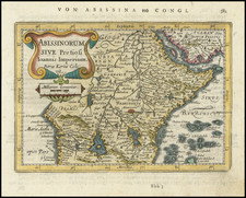
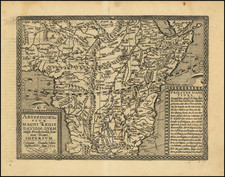
This map blends accurate geographical knowledge with some misunderstandings or errors, which were not uncommon for European maps of Africa from the 17th century, coming at a time when maps of partially known regions combined firsthand accounts from travelers with speculative or secondhand information, leading to a patchwork understanding of the continent's geography.
Nubia is a region situated along the Nile river, covering parts of present-day southern Egypt and northern Sudan. In the 17th century, it would have primarily been understood as the stretch of the Nile Valley between Aswan in southern Egypt and Khartoum in central Sudan. The Upper Nile River Valley describes the part of the Nile that flows northwards from its sources in central Africa towards the Mediterranean Sea. However, it's worth noting that the exact sources of the Nile, especially the White Nile, were not precisely known to Europeans in the 17th century, with clear discoveries only emerging in the 19th century.
The names "Desertum Zeu Iadie" and "Desertum Gorham" aren't commonly recognized in contemporary or classical accounts of the region. These might be interpretations or transliterations of local or Arabic names used during that time. The 17th-century mapping often combined firsthand accounts, older maps, and sometimes speculative or incorrect information.
This map, based on the description, seems to mix accurate geographical knowledge with some misunderstandings or errors. Such discrepancies were not uncommon for European maps of Africa from the 17th century, as they often blended firsthand traveler accounts with secondhand or speculative information, creating an uneven understanding of the continent's geography.