|
||

|

|
|

|
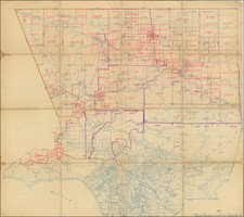
Mapping the Sierras and the Owens Valley (with Mona County!)
This scarce map from the Atlas of the Pacific Coast provides an interesting window into a transformative era in California's history. This map records a fascinating snapshot into the local history, underscored by its distinct features: the prominent coloring by counties, incomplete township survey lines, and the rich topographical details of the Sierra Nevada region.
The remoteness of the region, which was then a haven for miners, ranchers and small agriculture, is seen in the still incomplete US Geological Survey township survey lines for areas such as Death Valley, The White Mountains, Butte Valley, etc. These regions, largely unexplored or simply hard to access, would in the coming years be more comprehensively documented, shedding light on their unique landscapes.
At the heart of this map lies the magnificent Sierra Nevada Mountain Range, stretching from Yosemite and Mt. Hoffman in the north down to Volunteer Hills and Monache Peak in the south. This mountain range houses some of the tallest peaks in California, with Mt. Whitney standing out as the highest.
Owens Lake, displayed in its full grandeur on the map, hints at a pre-modern period before Los Angeles' infamous water acquisition. The history of this "water grab" dates back to the early 20th century when Los Angeles, in a bid to address its growing water needs, diverted the Owens River. This act would lead to the eventual drying up of Owens Lake, transforming it into a salt flat and leaving the once-thriving communities in Owens Valley in ruin.
The map further portrays the Carson & Colorado Railroad, extending southward to Keeler on Owens Lake. Established in the 1880s, this narrow-gauge railroad was intended to be a conduit for mining outputs from the region, particularly the silver from the Esmeralda district. Keeler, a once prosperous town fueled by the mining industry and the railroad's advent, would also face decline, particularly following the decline of the mining industry and the drying up of Owens Lake.
Another point of intrigue on the map is the high mountain tunnel noted east of Yosemite. While specific details about this tunnel from the map's context might be sparse, it's likely that such infrastructures were significant engineering undertakings in the era and would've been crucial for transportation and possibly mining activities.
The presence of numerous communities in the Owens Valley underscores a once vibrant region. However, the impending water rights issues in the subsequent decades would drastically reshape the landscape, both literally and sociopolitically. This map from 1892, therefore, captures a California on the cusp of great change, making it a significant artifact for historians, geographers, and all those keen on the Golden State's past.
![[ Ski Poster ] Mammoth California](https://storage.googleapis.com/raremaps/img/small/97884.jpg)
![[Charles Lindbergh - 1st Trans-Atlantic Flight - Printed on Linen]](https://storage.googleapis.com/raremaps/img/small/69233.jpg)