|
||

|

|
|

|
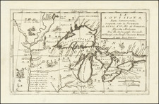
Carte Des Lacs Du Canada Pour sevir a l'Histoire Generale des Voyages… 1757, produced in Paris by Jacques Nicolas Bellin, provides a noteworthy cartographic depiction of the Great Lakes, and stands as a seminal work in the French mapping of North America during the 18th century. This map, a refinement upon the contributions of earlier cartographers like De l'Isle, denotes the leaps in geographical understanding and the blending of empirical data with some persisting myths of the region.
The mid-18th century was a crucial period for European exploration and colonization in North America, with the French playing a dominant role in the cartographic representation of the continent. Bellin's map was a significant progression in the illustration of New France, drawing extensively from the manuscript work of Chaussegros de Lery, the chief engineer of the army in New France. The inclusion of detailed features, settlements, and indigenous territories shed light on French interactions and understandings of the region.
A notable characteristic of Bellin's rendition of the Great Lakes is the incorporation of geographic anomalies, such as the mythical islands of Philippeaux and Pontchartrain in Lake Superior, and an intriguing elevated plateau in the Michigan Peninsula. While such inclusions highlight the challenges of mapping uncharted territories and the influence of prevailing myths, they don't overshadow the map's broader accuracy. Compared to its contemporaries, Bellin's portrayal was markedly advanced, offering a more precise depiction of the Great Lakes, and thus anchoring its position as one of the most influential and visually compelling cartographic pieces of the region.
Jacques-Nicolas Bellin (1703-1772) was among the most important mapmakers of the eighteenth century. In 1721, at only the age of 18, he was appointed Hydrographer to the French Navy. In August 1741, he became the first Ingénieur de la Marine of the Dépôt des cartes et plans de la Marine (the French Hydrographic Office) and was named Official Hydrographer of the French King.
During his term as Official Hydrographer, the Dépôt was the one of the most active centers for the production of sea charts and maps in Europe. Their output included a folio-format sea atlas of France, the Neptune Francois. He also produced a number of sea atlases of the world, including the Atlas Maritime and the Hydrographie Francaise. These gained fame and distinction all over Europe and were republished throughout the eighteenth and even in the nineteenth century.
Bellin also produced smaller format maps such as the 1764 Petit Atlas Maritime, containing 580 finely-detailed charts. He also contributed a number of maps for the 15-volume Histoire Generale des Voyages of Antoine François Prévost.
Bellin set a very high standard of workmanship and accuracy, cementing France's leading role in European cartography and geography during this period. Many of his maps were copied by other mapmakers across the continent.
![[ Cook's Discoveries in Russian America ] Chart of the NW Coast of America and the NE Coast of Asia explored in the Years 1778 & 1779 . . .](https://storage.googleapis.com/raremaps/img/small/68831.jpg)